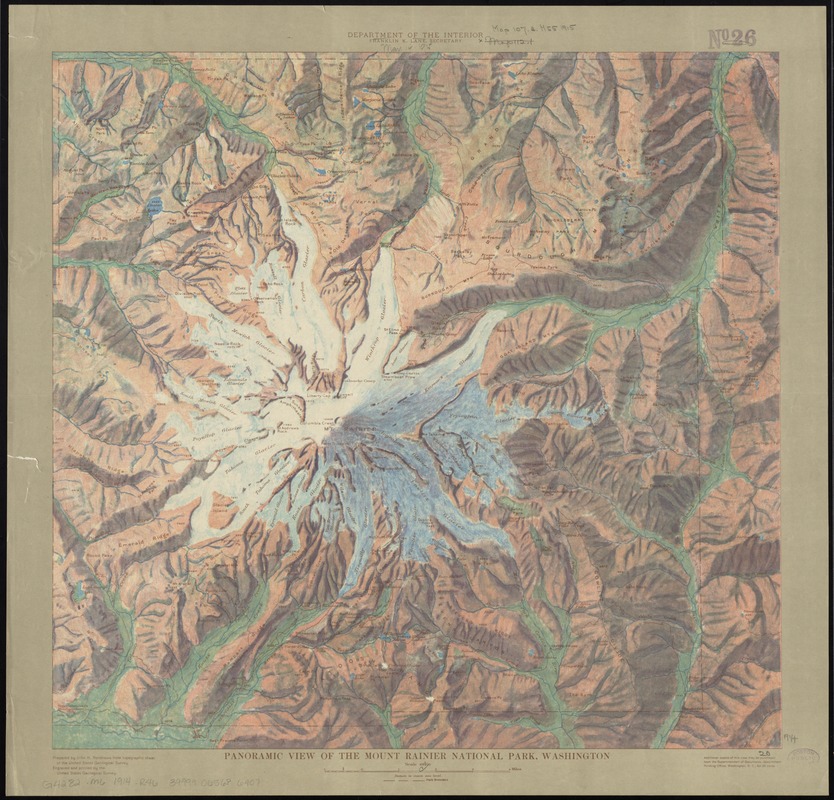
Panoramic view of the Mount Rainier National Park, Washington
Item Information
- Title:
- Panoramic view of the Mount Rainier National Park, Washington
- Description:
-
Regions and Seasons: Snowfall is another component of precipitation data found on weather maps, and is critical to a location’s resistance to drought during warm months. Mount Rainier, a national park, is an active volcano and the most glaciated peak in the lower forty-eight states. The Washington state mount was illustrated by topographer John Renshawe in 1914 during his work for the U.S. Geological Survey. Renshawe has applied color in a painterly manner to indicate relief, making this map look more like a work of art than a typical topographic map which used contour lines and minimal color to indicate relief.
- Creator:
- Renshawe, John H.
- Name on Item:
-
prepared by John H. Renshawe from topographic sheet of the United States Geological Survey.
- Date:
-
[1914]
- Format:
-
Maps/Atlases
- Location:
-
Boston Public Library
Norman B. Leventhal Map Center - Collection (local):
-
Norman B. Leventhal Map Center Collection
- Subjects:
-
Mount Rainier National Park (Wash.)--Maps
1914
- Places:
-
Mount Rainier National Park
- Extent:
- 1 map : col. ; 49 x 51 cm.
- Terms of Use:
-
No known copyright restrictions.
No known restrictions on use.
- Publisher:
-
[Washington, D.C.] :
United States Geological Survey ; [For sale by] the Supt. of Docs., G.P.O.
- Scale:
-
Scale 1:62,500
- Language:
-
English
- Notes:
-
Relief shown by spot heights and pictorially.
- Notes (date):
-
This date is inferred.
- Notes (exhibitions):
-
Exhibited: "Regions and Seasons: Mapping Climate through History" organized by the Norman B. Leventhal Map Center at the Boston Public Library, 2017.
- Identifier:
-
06_01_011505
- Call #:
-
G4282.M6 1914 .R46
- Barcode:
-
39999065686907