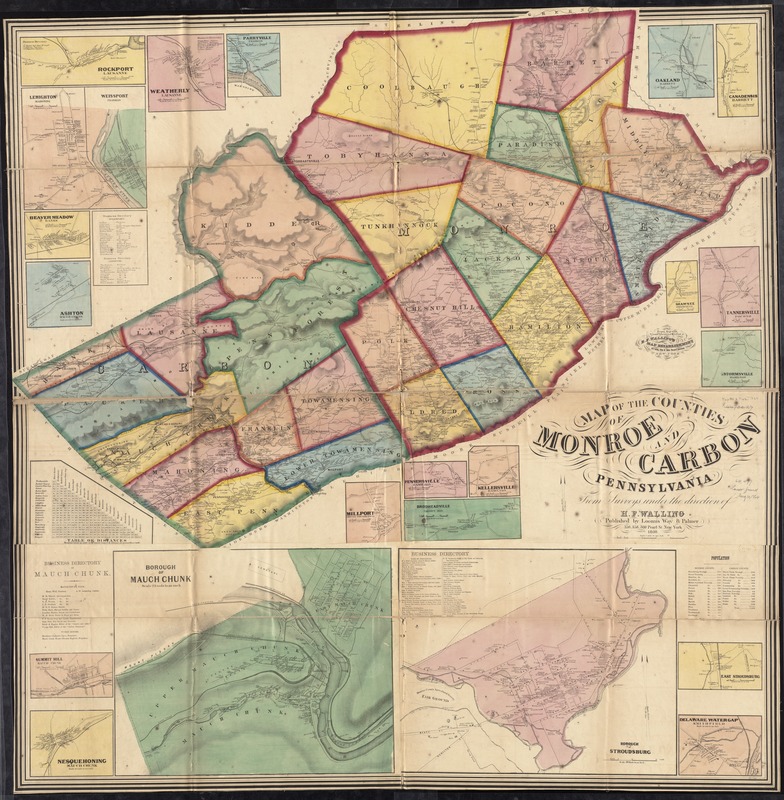
Map of the counties of Monroe and Carbon, Pennsylvania
Item Information
- Title:
- Map of the counties of Monroe and Carbon, Pennsylvania
- Creator:
- Walling, Henry Francis, 1825-1888
- Name on Item:
-
from surveys under the direction of H.F. Walling ; drawn, engraved, colored, and mounted at H.F. Walling's Map Establishment ... New York.
- Date:
-
1860
- Format:
-
Maps/Atlases
- Location:
-
Boston Public Library
Norman B. Leventhal Map Center - Collection (local):
-
Norman B. Leventhal Map Center Collection
- Subjects:
-
Landowners--Pennsylvania--Monroe County--Maps
Landowners--Pennsylvania--Carbon County--Maps
Cities and towns--Pennsylvania--Monroe County--Maps
Cities and towns--Pennsylvania--Carbon County--Maps
Villages--Pennsylvania--Monroe County--Maps
Villages--Pennsylvania--Carbon County--Maps
Landowners--Pennsylvania--Stroudsburg--Maps
Landowners--Pennsylvania--Jim Thorpe--Maps
Monroe County (Pa.)--Maps
Carbon County (Pa.)--Maps
Stroudsburg (Pa.)--Maps
Jim Thorpe (Pa.)--Maps
- Places:
-
Monroe (county)Stroudsburg
Carbon (county)Jim Thorpe
- Extent:
- 1 map on 4 sheets : hand col. ; 137 x 137 cm.
- Terms of Use:
-
No known copyright restrictions.
No known restrictions on use.
- Publisher:
-
New York :
Loomis, Way & Palmer
- Scale:
-
Scale [1:63,360]. 1 mile to 1 in.
- Language:
-
English
- Notes:
-
General-content county map also showing rural buildings and householders' names; the Stroudsburg and Mauch Chunk (name later changed to Jim Thorpe) borough insets show building coverage and occupants' names.
Relief shown by hachures.
Hand col. to emphasize township boundaries and territories.
"Entered according to Act of Congress A.D. 1860 by H.F. Walling in the ... Southern District of New York."
BPL copy assembled, sectioned to 4 sheets and mounted on cloth.
Includes population table, distance table, local business directories, and 21 village/borough insets.
- Identifier:
-
06_01_011513
- Call #:
-
G3823.M6 1860 .W35
- Barcode:
-
39999065686964
- LCCN:
-
2012590202