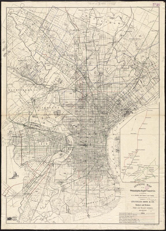
Official map of the Philadelphia Rapid Transit Co
Item Information
- Title:
- Official map of the Philadelphia Rapid Transit Co
- Creator:
- Philadelphia Rapid Transit Company
- Name on Item:
-
as furnished by W.S. Twining, chief engineer of the company.
- Date:
-
1904
- Format:
-
Maps/Atlases
- Location:
-
Boston Public Library
Norman B. Leventhal Map Center - Collection (local):
-
Norman B. Leventhal Map Center Collection
- Subjects:
-
Philadelphia Rapid Transit Company--Maps
Local transit--Pennsylvania--Philadelphia--Maps
Local transit--Pennsylvania--Philadelphia Metropolitan Area--Maps
Railroads--Pennsylvania--Philadelphia--Maps
Railroads, Elevated--Pennsylvania--Philadelphia--Maps
Subways--Pennsylvania--Philadelphia--Maps
Philadelphia (Pa.)--Maps
Philadelphia Metropolitan Area (Pa.)--Maps
- Places:
-
Philadelphia (county)Philadelphia
- Extent:
- 1 map : col. ; 104 x 75 cm.
- Terms of Use:
-
No known copyright restrictions.
No known restrictions on use.
- Publisher:
-
Philadelphia, Pa :
Chandler Bros. & Co.
- Scale:
-
Scale [ca. 1:21,000]
- Language:
-
English
- Notes:
-
Oriented with north towards the upper left.
Distance from City Hall show by concentric circles.
Base map copyrighted by J.L. Smith, 1904.
Inset: [Transportation outline of area to the north].
- Identifier:
-
06_01_011496
- Call #:
-
G3824.P5P1 1904 .P45
- Barcode:
-
39999065685032