Map of Pickaway County, Ohio
Item Information
- Title:
- Map of Pickaway County, Ohio
- Description:
-
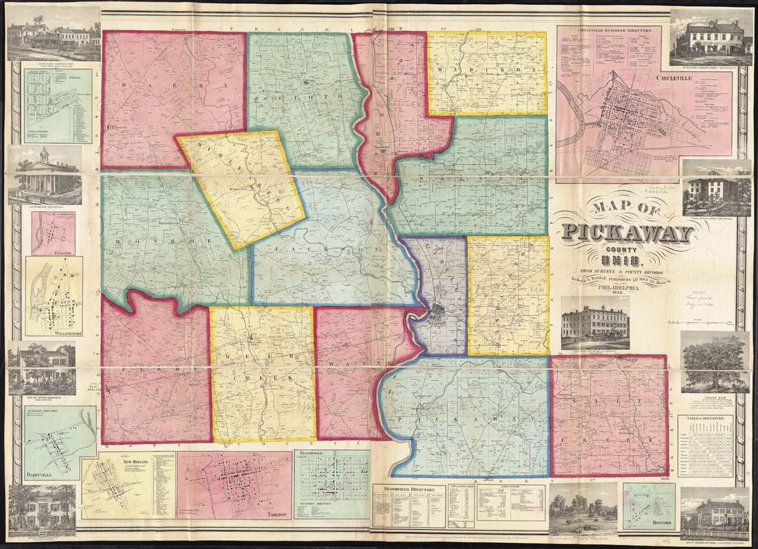
America Transformed: Pickaway County, located in central Ohio about 25 miles south of Columbus, provides a good example of a rural Midwestern county where the economy was based on diversified agriculture during the first half of 19th century. The statistical tables along the bottom margin of this land ownership map indicate that the county had a population of 21,000 and farms were valued at $6 million. Agricultural production included a variety of livestock (horses, cows, oxen, sheep, and swine) and crops (corn, wheat, rye, oats, hay, and potatoes). The map also displays the boundaries of individual landholdings, indicating that most were small farms containing several hundred acres.
- Creator:
- Kellogg & Randall
- Name on Item:
-
from surveys and county records.
- Date:
-
1858
- Format:
-
Maps/Atlases
- Location:
-
Boston Public Library
Norman B. Leventhal Map Center - Collection (local):
-
Norman B. Leventhal Map Center Collection
- Subjects:
-
Buildings--Ohio--Pickaway County--Pictorial works
Landowners--Ohio--Pickaway County--Maps
Real property--Ohio--Pickaway County--Maps
Cities and towns--Ohio--Pickaway County--Maps
Pickaway County (Ohio)--Maps
- Places:
-
Pickaway (county)
- Extent:
- 1 map on 2 sheets : color ; 95 x 134 cm.
- Terms of Use:
-
No known copyright restrictions.
No known restrictions on use.
- Publisher:
-
Philadelphia :
Kellogg & Randall, publishers,
- Scale:
-
Scale [ca. 1:43,000]
- Language:
-
English
- Notes:
-
Entered according to Act of Congress in the year 1858 by R.P. Smith in the clerks office of the District Court of the eastern district of Pennsylvania.
Includes Bloomfield directory, 1850 population and agriculture statistics, distance table, 9 insets and 10 views of public, commercial, and residential properties.
Insets: Genoa -- Palestine -- Williamsport -- Darbyville -- New Holland -- Tarlton -- Bloomfield -- Ringgold -- Circleville.
BPL copy assembled, sectioned into 3 pieces and mounted on cloth.
- Notes (exhibitions):
-
Exhibited: "America transformed. Part 1: the United States expands westward," organized by the Norman B. Leventhal Map & Education Center at the Boston Public Library, 2019.
- Identifier:
-
06_01_011287
- Call #:
-
G4083.P5 1858 .K45
- Barcode:
-
39999065683524
- LCCN:
-
2012592241


