A geological and topographical rough survey map of the Hinckley Coal Lands near Warsaw, Coshocton County, Ohio
Item Information
- Title:
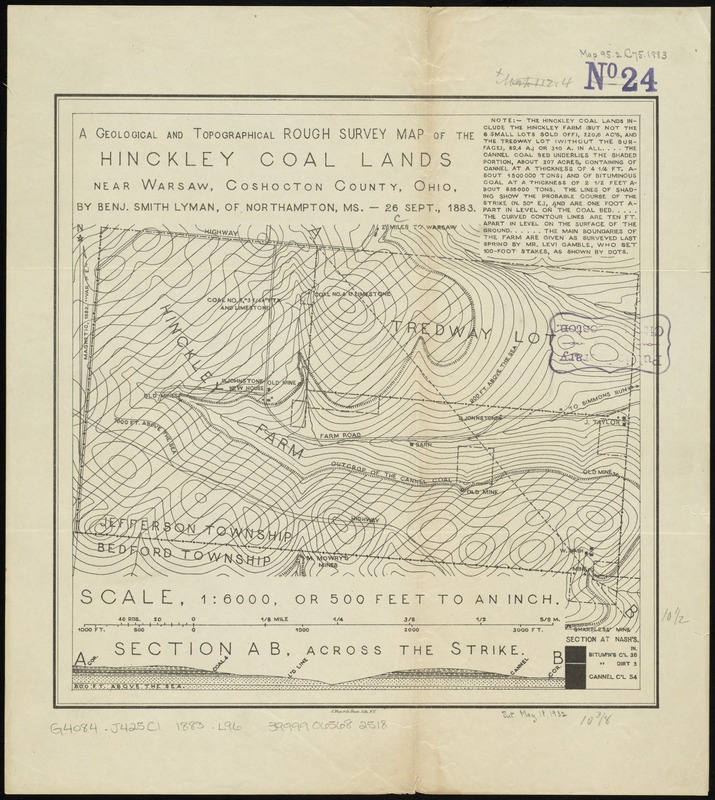
- A geological and topographical rough survey map of the Hinckley Coal Lands near Warsaw, Coshocton County, Ohio
- Creator:
- Lyman, Benjamin Smith, 1835-1920
- Name on Item:
-
by Benj. Smith Lyman, of Northampton, MS. - 26 Sept., 1883.
- Date:
-
[1883]
- Format:
-
Maps/Atlases
- Location:
-
Boston Public Library
Norman B. Leventhal Map Center - Collection (local):
-
Norman B. Leventhal Map Center Collection
- Subjects:
-
Geology--Ohio--Coshocton County--Maps
Coal mines and mining--Ohio--Coshocton County--Maps
Jefferson (Coshocton County, Ohio : Township)--Maps
- Places:
-
Coshocton (county)
Township of Jefferson
- Extent:
- 1 map ; 27 x 27 cm.
- Terms of Use:
-
No known copyright restrictions.
No known restrictions on use.
- Publisher:
-
Northampton, Mass :
Benjamin Smith Lyman
- Scale:
-
Scale 1:6,000
- Language:
-
English
- Notes:
-
Relief shown by contours.
Includes text and cross-section.
- Notes (date):
-
This date is inferred.
- Identifier:
-
06_01_011209
- Call #:
-
G4084.J425C1 1883 .L96
- Barcode:
-
39999065682518


