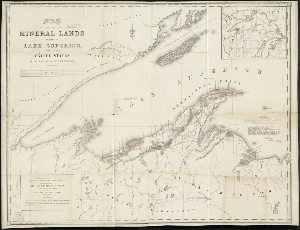
Map of that part of the mineral lands adjacent to Lake Superior, ceded to the United States by the treaty of 1842 with the Chippewas : comprising that district lying between Chocolate River and Fond du Lac, under the superintendency of Genl. John Stockton, U.S. agent
Item Information
- Title:
- Map of that part of the mineral lands adjacent to Lake Superior, ceded to the United States by the treaty of 1842 with the Chippewas : comprising that district lying between Chocolate River and Fond du Lac, under the superintendency of Genl. John Stockton, U.S. agent
- Creator:
- Gray, A. B. (Andrew Belcher), 1820-1862
- Name on Item:
-
projected and drawn under the direction of George Talcott, Ordnance Bureau, by A.B. Gray ; assisted by John Seib.
- Date:
-
[1845]
- Format:
-
Maps/Atlases
- Location:
-
Boston Public Library
Norman B. Leventhal Map Center - Collection (local):
-
Norman B. Leventhal Map Center Collection
- Subjects:
-
Mines and mineral resources--Michigan--Upper Peninsula--Maps
Upper Peninsula (Mich.)--Maps
Superior, Lake--Maps
- Places:
-
upper peninsula (area)
Superior, Lake
- Extent:
- 1 map on 2 sheets : joined, hand col. ; 87 x 115 cm.
- Terms of Use:
-
No known copyright restrictions.
No known restrictions on use.
- Publisher:
-
Washington, D.C :
War Dept.
- Scale:
-
Scale [ca. 1:380,000]
- Language:
-
English
- Notes:
-
Relief shown by hachures.
Shows mining claims.
Inset: [Lake Superior region].
"Compiled from surveys and explorations made by direction of the War Department under the superintendence of the U.S. Agency at Copper Harbor; from U.S. surveys made by Dr. Houghton and Wm. A. Burt Esq.; from Nicollet's map of the Upper Mississippi River; and from Bayfield's charts of Lake Superior: vide accompanying report of 1845". (In U.S. 29th Cong., special session Senate 175, no. 461).
Includes errata for accompanying report (House document no. 211), signed by A.B. Gray, Surveyor & Asst. Supt., U.S. Mines.
Does not include ill. of Camp Gray that appears on other versions.
- Notes (date):
-
This date is inferred.
- Identifier:
-
06_01_011178
- Call #:
-
G4112.U6H1 1845 .G73
- Barcode:
-
39999065682609