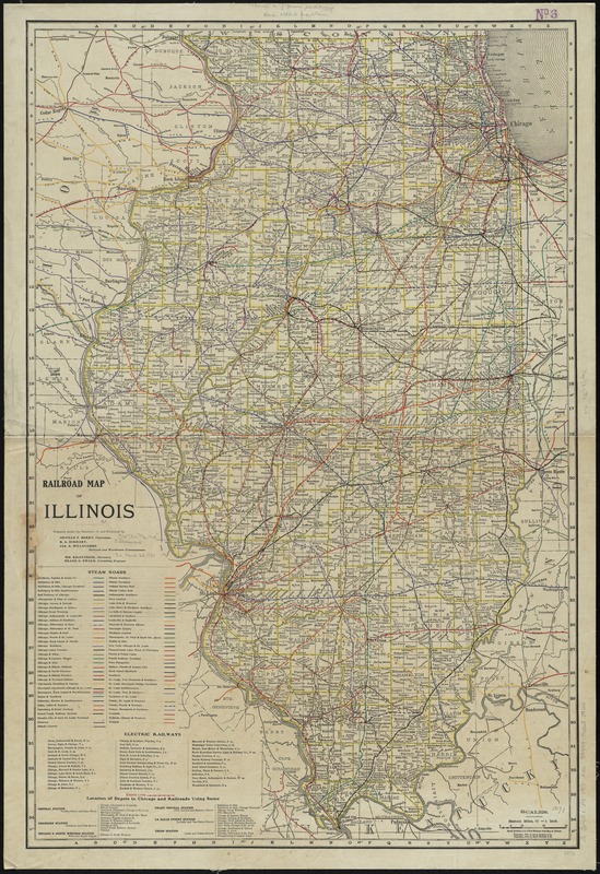
Railroad map of Illinois
Item Information
- Title:
- Railroad map of Illinois
- Title (alt.):
-
Rand, McNally & Co.'s new business atlas map of Illinois
New business atlas map of Illinois
- Creator:
- Rand McNally and Company
- Name on Item:
-
prepared under the direction of, and presented by Orville F. Berry, B.A. Eckhart, Jas. A. Willoughby, Railroad and Warehouse Commissioners.
- Date:
-
[ca. 1910]
- Format:
-
Maps/Atlases
- Location:
-
Boston Public Library
Norman B. Leventhal Map Center - Collection (local):
-
Norman B. Leventhal Map Center Collection
- Subjects:
-
Railroads--Illinois--Maps
Illinois--Maps
- Places:
-
Illinois
- Extent:
- 1 map : col. ; 94 x 62 cm.
- Terms of Use:
-
No known copyright restrictions.
No known restrictions on use.
- Publisher:
-
Chicago :
Rand McNally
- Scale:
-
Scale [1:633,600] 1 in. to 10 miles
- Language:
-
English
- Notes:
-
Includes lists of steam roads, electric railways, and location of depots in Chicago.
Electric railways indexed.
- Identifier:
-
06_01_011152
- Call #:
-
G4101.P3 1910 .R36
- Barcode:
-
39999065682922
![[Illinois]](https://bpldcassets.blob.core.windows.net/derivatives/images/commonwealth:4m90f716w/image_thumbnail_300.jpg)