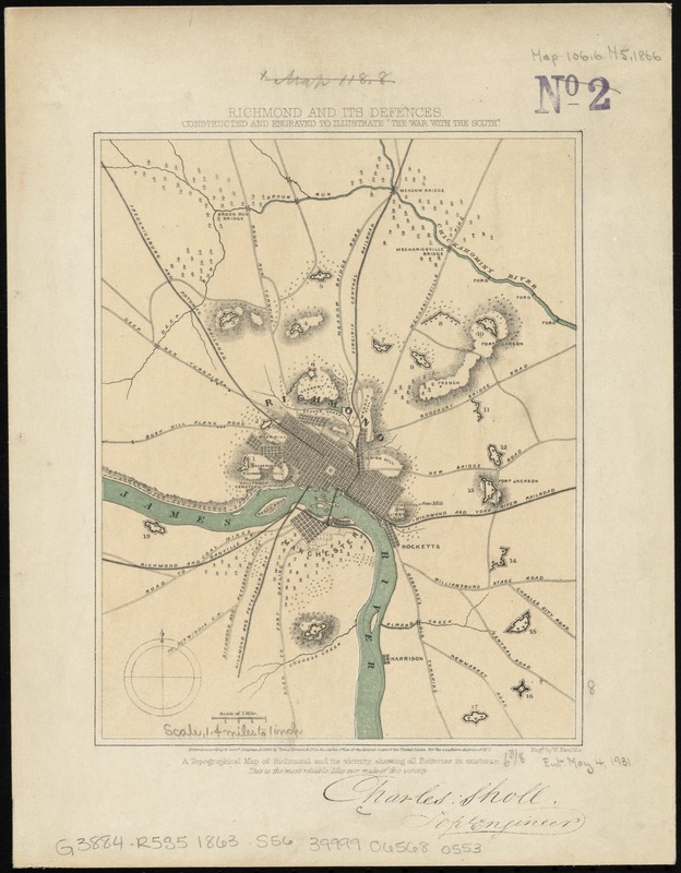
Richmond and its defences : constructed and engraved to illustrate "The war with the South"
Item Information
- Title:
- Richmond and its defences : constructed and engraved to illustrate "The war with the South"
- Title (alt.):
-
Richmond and its defenses
Topographical map of Richmond and its vicinity, showing all batteries in existence : this is the most reliable map ever made of this vicinity
- Creator:
- Sholl, Charles.
- Name on Item:
-
Charles Sholl, topl. engineer ; engd. by W. Kemble.
- Date:
-
[1863–1867]
- Format:
-
Maps/Atlases
- Location:
-
Boston Public Library
Norman B. Leventhal Map Center - Collection (local):
-
Norman B. Leventhal Map Center Collection
- Subjects:
-
Fortification--Virginia--Richmond--Maps
Richmond (Va.)--History--Civil War, 1861-1865--Maps
- Places:
-
Richmond
- Extent:
- 1 map : col. ; 21 x 17 cm.
- Terms of Use:
-
No known copyright restrictions.
No known restrictions on use.
- Publisher:
-
New York :
Virtue & Yorston
- Scale:
-
Scale [ca. 1:87,000]
- Language:
-
English
- Notes:
-
Entered according to act of Congress AD. 1863, by Virtue, Yorston & Co. in the clerk's office of the district court of the United States, for the southern district of N.Y.
Signed (facsimile): Charles: Sholl, Topl. Engineer.
Relief shown by hachures.
Shows roads, rivers, railroads and batteries.
From: Tomes, Robert. The war with the South. New York, Virtue & Yorston, 1862-1867. v. 2, between p. 236 and 237.
- Notes (date):
-
This date is inferred.
- Identifier:
-
06_01_010993
- Call #:
-
G3884.R5S5 1863 .S56
- Barcode:
-
39999065680553