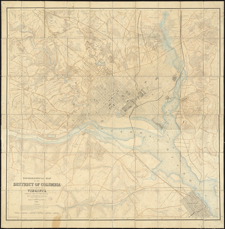
Topographical map of the District of Columbia and a portion of Virginia
Item Information
- Title:
- Topographical map of the District of Columbia and a portion of Virginia
- Creator:
- Greene, F. V. (Francis Vinton), 1850-1921
- Name on Item:
-
compiled under the direction of Major G.J. Lydecker, Corps of Engineers, Engineer Commissioner D.C., by Captain F.V. Greene, Corps of Engineers ; drawn by W.T.O. Bruff.
- Date:
-
1884
- Format:
-
Maps/Atlases
- Location:
-
Boston Public Library
Norman B. Leventhal Map Center - Collection (local):
-
Norman B. Leventhal Map Center Collection
- Subjects:
-
Real property--Washington (D.C.)--Maps
Landowners--Washington (D.C.)--Maps
Washington (D.C.)--Maps
Arlington County (Va.)--Maps
- Places:
-
Arlington (county)
Washington
- Extent:
- 1 map : col. ; 102 x 102 cm.
- Terms of Use:
-
No known copyright restrictions.
No known restrictions on use.
- Publisher:
-
Washington? :
[s.n.]
- Scale:
-
Scale [1:15,840]. 4 in. to 1 mile
- Language:
-
English
- Notes:
-
Partial cadastral map showing landowners' names in rural areas of D.C.
Also shows density of built-up area in city.
Relief shown by contours. Depths shown by soundings.
Oriented with north toward the upper left.
Originally printed on 2 sheets.
Includes source materials note.
- Identifier:
-
06_01_010841
- Call #:
-
G3850 1884 .G74
- Barcode:
-
39999065678367
- LCCN:
-
88693447