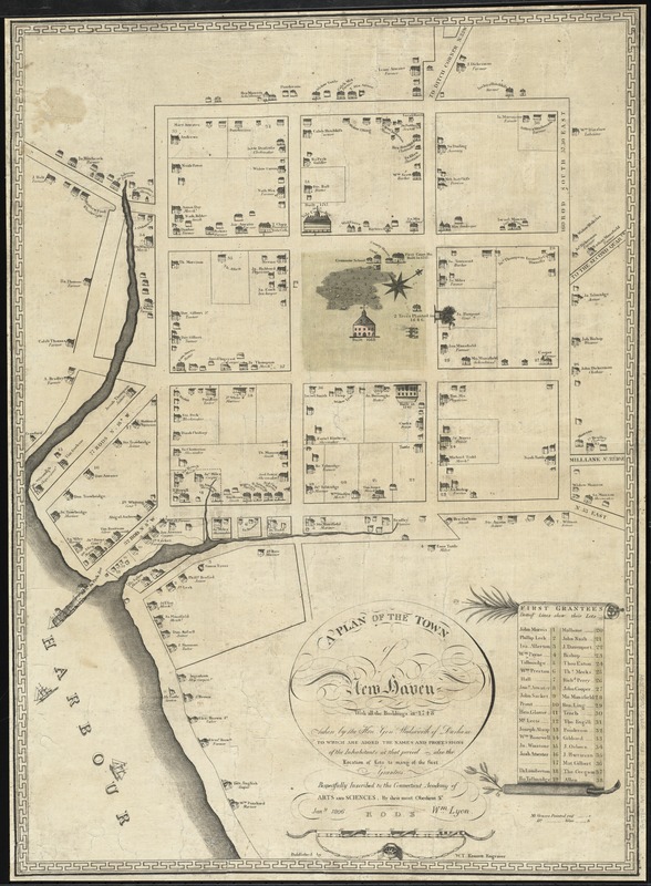
A plan of the town of New Haven : with all the buildings in 1748 taken by the Hon. Gen. Wadsworth of Durham to which are added the names and professions of the inhabitants at that period : also the location of lots to many of the first grantees
Item Information
- Title:
- A plan of the town of New Haven : with all the buildings in 1748 taken by the Hon. Gen. Wadsworth of Durham to which are added the names and professions of the inhabitants at that period : also the location of lots to many of the first grantees
- Creator:
- Lyon, Wm. (William)
- Name on Item:
-
respectfully inscribed to the Connecticut Academy of Arts and Sciences, by their most obedient s[ervan]t, Wm. Lyon, Jany. 1806.
- Date:
-
1806
- Format:
-
Maps/Atlases
- Location:
-
Boston Public Library
Norman B. Leventhal Map Center - Collection (local):
-
Norman B. Leventhal Map Center Collection
- Subjects:
-
Historic buildings--Connecticut--New Haven--Maps
Real property--Connecticut--New Haven--Maps
Landowners--Connecticut--New Haven--Maps
New Haven (Conn.)--History--Maps
- Places:
-
New Haven (county)New Haven
- Extent:
- 1 map ; 66 x 48 cm.
- Terms of Use:
-
No known copyright restrictions.
No known restrictions on use.
- Publisher:
-
[New Haven?] :
Published by T. Kensett, engraver
- Scale:
-
Scale [ca. 1:2,586]
- Language:
-
English
- Notes:
-
Pictorial historical map that shows historic buildings, historic trees, and ships. Also shows names and professions of lot owners.
Oriented with north toward the upper right.
Includes historical notes and index to lots of first grantees with names of grantees indicated.
Only central block and list of first grantees are colored.
- Identifier:
-
06_01_010860
- Call #:
-
G3784.N4 1748 .L96 1806
- Barcode:
-
39999065678094
- LCCN:
-
2011589297


