The isthmus of Nova Scotia
This map is also available in American Revolutionary Geographies Online (ARGO), a collections portal especially built for material relating to the American Revolutionary War Era. Visit ARGO to learn more about this item and explore the historical geography of North America in the late eighteenth century.
Item Information
- Title:
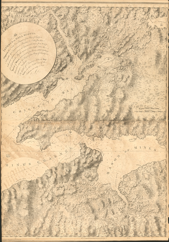
- The isthmus of Nova Scotia
- Publisher:
- Des Barres, Joseph F. W. (Joseph Frederick Wallet), 1722-1824
- Date:
-
1777
- Format:
-
Maps/Atlases
- Location:
- Library of Congress Geography and Map Division
- Collection (local):
-
Library of Congress Geography and Map Division
- Subjects:
-
Chignecto Bay (N.B. and N.S.)--Maps
Chignecto Isthmus (N.B. and N.S.)--Maps
Minas Basin (N.S.)--Maps
Minas Channel (N.S.)--Maps
Coasts--Nova Scotia--Maps
- Places:
-
CanadaMinas Channel
CanadaMinas Basin (bay)
CanadaChignecto Bay
Chignecto Isthmus
- Extent:
- 1 map ; 107 x 77 cm.
- Terms of Use:
-
No known copyright restrictions.
This work is licensed for use under a Creative Commons Attribution Non-Commercial Share Alike License (CC BY-NC-SA).

- Publisher:
-
[London] :
J.F.W. Des Barres
- Scale:
-
Scale [ca. 1:500,000]
- Language:
-
English
- Catalog Record:
-
https://lccn.loc.gov/75332521
- Notes:
-
State 2. The area east of Eden Cove in Minas Bay has been redrawn, the name "Partridge Island" reengraved, the words "Cape Baptist" added, and in anchorage inserted on the west side of the island.

![[Chignecto Bay and vicinity]](https://bpldcassets.blob.core.windows.net/derivatives/images/commonwealth:z603vj91v/image_thumbnail_300.jpg)
