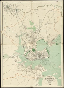
Map of Portland, Me. and vicinity
Item Information
- Title:
- Map of Portland, Me. and vicinity
- Creator:
- Tower, Fred L.
- Name on Item:
-
F.L. Tower, del.
- Date:
-
1902
- Format:
-
Maps/Atlases
- Location:
-
Boston Public Library
Norman B. Leventhal Map Center - Collection (local):
-
Norman B. Leventhal Map Center Collection
- Subjects:
-
Portland (Me.)--Maps
- Places:
-
Cumberland (county)Portland
- Extent:
- 1 map ; 70 x 67 cm.
- Terms of Use:
-
No known copyright restrictions.
No known restrictions on use.
- Publisher:
-
[Portland, Me.] :
Portland Directory Company
- Scale:
-
Scale [ca. 1:12,000]
- Language:
-
English
- Notes:
-
Shows city districts and radial distances from City Hall.
Oriented with north to the upper right.
Includes index to points of interest.
- Identifier:
-
06_01_010448
- Call #:
-
G3734.P8 1902 .T69
- Barcode:
-
39999065672709