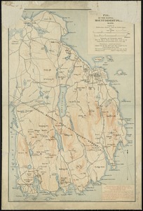
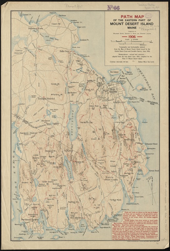
Path map of the eastern part of Mount Desert Island, Maine
Item Information
- Title:
- Path map of the eastern part of Mount Desert Island, Maine
- Creator:
- Bates, Waldron.
- Name on Item:
-
compiled by Waldron Bates, Edward L. Rand and Herbert Jaques.
- Date:
-
1906
- Format:
-
Maps/Atlases
- Location:
-
Boston Public Library
Norman B. Leventhal Map Center - Collection (local):
-
Norman B. Leventhal Map Center Collection
- Subjects:
-
Trails--Maine--Mount Desert Island--Maps
Mount Desert Island (Me.)--Maps
- Places:
-
Hancock (county)Mount Desert Island (island)
- Extent:
- 1 map : col. ; 63 x 41 cm.
- Terms of Use:
-
No known copyright restrictions.
No known restrictions on use.
- Publisher:
-
Boston :
Geo. H. Walker & Co.
- Scale:
-
Scale 1:29,000
- Language:
-
English
- Notes:
-
Relief shown by contours, hachures and spot heights.
"Topography and hydrography adapted from the map of Mount Desert Island issued by the United States Coast and Geodetic Survey, June, 1882."
"Nomenclature, revised and corrected, adapted from the map dated June, 1893, compiled for the flora of Mount Desert Island."
- Identifier:
-
06_01_010432
- Call #:
-
G3732.M6 1906 .B381
- Barcode:
-
39999065671040