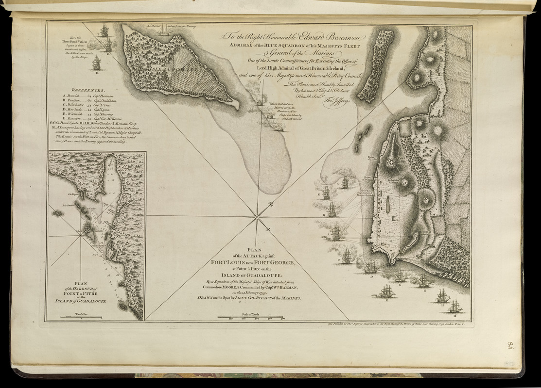
Plan of the attack against Fort Louis now Fort George, at Point à Pitre on the island of Guadaloupe : by a squadron of His Majesty's ships of war, detached from Commodore Moore & commanded by Capt. Wm. Harman, on the 14 February 1759
This map is also available in American Revolutionary Geographies Online (ARGO), a collections portal especially built for material relating to the American Revolutionary War Era. Visit ARGO to learn more about this item and explore the historical geography of North America in the late eighteenth century.
Item Information
- Title:
- Plan of the attack against Fort Louis now Fort George, at Point à Pitre on the island of Guadaloupe : by a squadron of His Majesty's ships of war, detached from Commodore Moore & commanded by Capt. Wm. Harman, on the 14 February 1759
- Creator:
- Rycaut, Edward, fl. 1756-1763
- Contributor:
- Jefferys, Thomas, -1771
- Contributor:
- Sayer, Robert, 1725-1794
- Name on Item:
-
drawn on the spot by Lieut. Col. Rycaut of the Marines
- Date:
-
[1768]
- Format:
-
Maps/Atlases
- Location:
-
Boston Public Library
Norman B. Leventhal Map Center - Collection (local):
-
Norman B. Leventhal Map Center Collection
- Subjects:
-
Seven Years' War, 1756-1763--Maps--Early works to 1800
West Indies--History--1756-1763--Maps--Early works to 1800
Pointe-à-Pitre (Guadeloupe)--Maps--Early works to 1800
- Places:
-
Guadeloupe (territory)Grande-Terre (island)Pointe-à-Pitre
- Extent:
- 1 map ; 33 x 47 cm.
- Terms of Use:
-
No known copyright restrictions.
No known restrictions on use.
- Publisher:
-
London :
Thos. Jefferys, Geographer to His Royal Highness the Prince of Wales near Charing Cross
- Scale:
-
Scale [ca. 1:6,500]
- Language:
-
English
- Notes:
-
Shows entrenchments, batteries, and bombardment by ships.
Relief shown by hachures and pictorially. Depths shown by soundings.
Oriented with north to the upper right.
Inset: Plan of the harbour of Point a Pitre on the island of Guadeloupe.
Includes references A-K and notes.
Dedication "To the Right Honourable Edward Boscawen ..."
Appears in Jefferys' General topography of North America and the West Indies. London: Printed for Robert Sayer, ... and Thomas Jefferys, 1768.
- Notes (date):
-
This date is inferred.
- Notes (citation):
-
Phillips. List of maps of America, p. 292
Phillips, 1196
- Identifier:
-
4000137_0110r
- Call #:
-
G1105 .J4 1768
- Barcode:
-
30000003256624