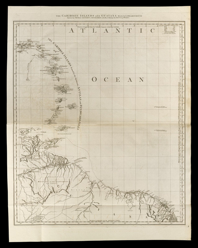
The Caribbee Islands and Guayana
Item Information
- Title:
- The Caribbee Islands and Guayana
- Creator:
- Delarochette, L. (Louis), 1731-1802
- Contributor:
- Jefferys, Thomas, -1771
- Contributor:
- Sayer, Robert, 1725-1794
- Name on Item:
-
drawn by L. Delarochette ; engraved by Thomas Jefferys, geographer to his Royal Highness the Prince of Wales
- Date:
-
[1768]
- Format:
-
Maps/Atlases
- Location:
-
Boston Public Library
Norman B. Leventhal Map Center - Collection (local):
-
Norman B. Leventhal Map Center Collection
- Subjects:
-
Antilles, Lesser--Maps--Early works to 1800
Venezuela--Maps--Early works to 1800
French Guiana--Maps--Early works to 1800
Guiana--Maps--Early works to 1800
Suriname--Maps--Early works to 1800
- Places:
-
Lesser Antilles (area)
Venezuela
Guyana
French Guiana (territory)
Suriname
- Extent:
- 1 map ; 70 x 59 cm.
- Terms of Use:
-
No known copyright restrictions.
No known restrictions on use.
- Publisher:
-
London :
Printed for Robert Sayer, ... and Thomas Jefferys
- Scale:
-
Scale [ca. 1:2,600,000]
- Language:
-
English
- Notes:
-
Cover the Lesser Antilles and parts of Venezuela and the Guianas.
Prime meridians: Lizard [Point, England] and Ferro.
Relief shown pictorially. Depths shown by soundings.
Appears in Jefferys' General topography of North America and the West Indies. London: Printed for Robert Sayer, ... and Thomas Jefferys, 1768.
- Notes (date):
-
This date is inferred.
- Notes (citation):
-
LC Maps of North America, 1969
Phillips, 1196
- Identifier:
-
4000137_0103
- Call #:
-
G1105 .J4 1768
- Barcode:
-
30000003256616