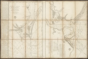
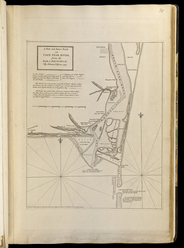
A new and exact plan of Cape Fear River, from the bar to Brunswick
This map is also available in American Revolutionary Geographies Online (ARGO), a collections portal especially built for material relating to the American Revolutionary War Era. Visit ARGO to learn more about this item and explore the historical geography of North America in the late eighteenth century.
Item Information
- Title:
- A new and exact plan of Cape Fear River, from the bar to Brunswick
- Creator:
- Hyrne, Edward
- Contributor:
- Jefferys, Thomas, -1771
- Contributor:
- Sayer, Robert, 1725-1794
- Name on Item:
-
by Edward Hyrne, 1749
- Date:
-
[1768]
- Format:
-
Maps/Atlases
- Location:
-
Boston Public Library
Norman B. Leventhal Map Center - Collection (local):
-
Norman B. Leventhal Map Center Collection
- Subjects:
-
Nautical charts--North Carolina--Cape Fear River Estuary--Early works to 1800
Cape Fear River Estuary (N.C.)--Maps--Early works to 1800
Fear, Cape (N.C.)--Maps--Early works to 1800
- Places:
-
Brunswick (county)Fear, Cape
- Extent:
- 1 map ; 39 x 32 cm.
- Terms of Use:
-
No known copyright restrictions.
No known restrictions on use.
- Publisher:
-
[London] :
Printed for Robt. Sayer in Fleet Street and Thos. Jefferys the corner of St. Martins Lane in the Strand
- Scale:
-
Scale [ca. 1:104,000]
- Language:
-
English
- Notes:
-
Includes notes and references.
Appears in Jefferys' General topography of North America and the West Indies. London: Printed for Robert Sayer, ... and Thomas Jefferys, 1768.
- Notes (date):
-
This date is inferred.
- Notes (citation):
-
LC Maps of North America, 1750-1789, 1503
Cumming, W.P. Southeast in early maps, 368
- Identifier:
-
4000137_0075
- Call #:
-
G1105 .J4 1768
- Barcode:
-
30000003254692