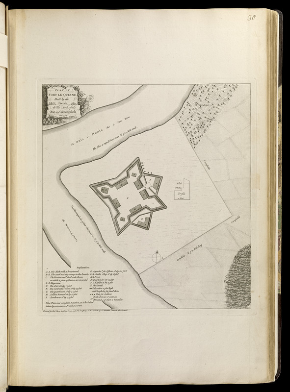
Plan of Fort le Quesne, built by the French at the fork of the Ohio and Monongahela in 1754
This map is also available in American Revolutionary Geographies Online (ARGO), a collections portal especially built for material relating to the American Revolutionary War Era. Visit ARGO to learn more about this item and explore the historical geography of North America in the late eighteenth century.
Item Information
- Title:
- Plan of Fort le Quesne, built by the French at the fork of the Ohio and Monongahela in 1754
- Creator:
- Stobo, Robert, 1726-1770
- Date:
-
[1768]
- Format:
-
Maps/Atlases
- Location:
-
Boston Public Library
Norman B. Leventhal Map Center - Collection (local):
-
Norman B. Leventhal Map Center Collection
- Subjects:
-
Pittsburgh (Pa.)--Maps--Early works to 1800
Fort Duquesne (Pa.)--History--French and Indian War, 1754-1763--Maps--Early works to 1800
- Places:
-
Allegheny (county)Pittsburgh
- Extent:
- 1 map ; 33 x 31 cm.
- Terms of Use:
-
No known copyright restrictions.
No known restrictions on use.
- Publisher:
-
[London] :
Printed for Robt. Sayer in Fleet Street and Thos. Jefferys at the corner of St. Martins Lane in the Strand
- Scale:
-
Scale [ca. 1:2,500]
- Language:
-
English
- Notes:
-
Based on the plan drawn by Robert Stobo while a prisoner of the French in 1754.
Table of references identifies buildings and features of the fort.
"This plan was sent from America, as it had been taken by some curious French deserters."
Inset: [Cross-section of fort wall].
Appears in Jefferys' General topography of North America and the West Indies. London: Printed for Robert Sayer, ... and Thomas Jefferys, 1768.
- Notes (date):
-
This date is inferred.
- Identifier:
-
4000137_0057
- Call #:
-
G1105 .J4 1768
- Barcode:
-
30000003792232