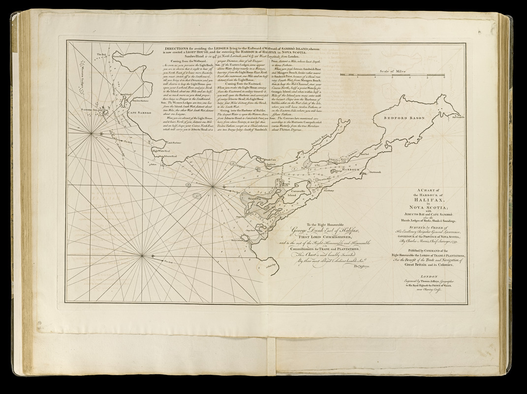
A chart of the harbour of Halifax in Nova Scotia : with Jebucto Bay and Cape Sambro also the islands, ledges of rocks, shoals & soundings
Item Information
- Title:
- A chart of the harbour of Halifax in Nova Scotia : with Jebucto Bay and Cape Sambro also the islands, ledges of rocks, shoals & soundings
- Creator:
- Morris, Charles
- Contributor:
- Jefferys, Thomas, -1771
- Contributor:
- Sayer, Robert, 1725-1794
- Name on Item:
-
survey'd, by order of his excellency Brigadier General Lawrence, governour of the province of Nova Scotia by Charles Morris, chief surveyor, 1759 ; engraved by Thomas Jefferys
- Date:
-
[1768]
- Format:
-
Maps/Atlases
- Location:
-
Boston Public Library
Norman B. Leventhal Map Center - Collection (local):
-
Norman B. Leventhal Map Center Collection
- Subjects:
-
Nautical charts--Nova Scotia--Halifax Harbour--Early works to 1800
Halifax Harbour (N.S.)--Maps--Early works to 1800
Halifax, George Montagu-Dunk, Earl of, 1716-1771
- Places:
-
CanadaHalifax Harbour (harbor)
- Extent:
- 1 map ; 40 x 60 cm.
- Terms of Use:
-
No known copyright restrictions.
No known restrictions on use.
- Publisher:
-
London :
Thomas Jefferys, geographer to His Royal Highness the Prince of Wales, near Charing Cross
- Scale:
-
Scale [ca. 1:72,000]
- Language:
-
English
- Notes:
-
State 1.
Oriented with north to the right.
Depths shown by soundings.
Includes directions for entering the harbor.
Dedication: To the right honourable George Dunk Earl of Halifax, first lord commissioner, and to the rest of the right honourable commissioners for trade and plantations this chart is most humbly inscribed by their most obliged & obedient humble servt. Thos. Jefferys.
Appears in Jefferys' General topography of North America and the West Indies. London: Printed for Robert Sayer, ... and Thomas Jefferys, 1768.
- Notes (date):
-
This date is inferred.
- Notes (citation):
-
Kershaw, K. Early printed maps of Canada, vol. 3, no. 820
Phillips, 1196
- Identifier:
-
4000137_0037
- Call #:
-
G1105 .J4 1768
- Barcode:
-
30000003254063