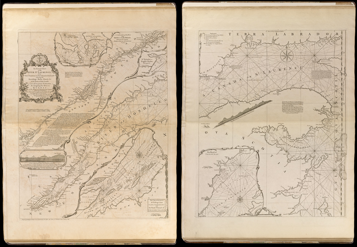
An exact chart of the river St. Laurence, from Fort Frontenac to the island of Anticosti shewing the soundings, rocks, shoals &c with views of the lands and all necessary instructions for navigating that river to Quebec
Item Information
- Title:
- An exact chart of the river St. Laurence, from Fort Frontenac to the island of Anticosti shewing the soundings, rocks, shoals &c with views of the lands and all necessary instructions for navigating that river to Quebec
- Creator:
- Jefferys, Thomas, -1771
- Name on Item:
-
engraved & published ... by Thos. Jefferys
- Date:
-
[1768]
- Format:
-
Maps/Atlases
- Location:
-
Boston Public Library
Norman B. Leventhal Map Center - Collection (local):
-
Norman B. Leventhal Map Center Collection
- Subjects:
-
Nautical charts--Saint Lawrence River--Early works to 1800
Saint Lawrence River--Maps--Early works to 1800
Saint Lawrence River Valley--Maps--Early works to 1800
- Places:
-
Saint Lawrence River
- Extent:
- 1 map on 2 sheets ; 60 x 95 cm.
- Terms of Use:
-
No known copyright restrictions.
This work is licensed for use under a Creative Commons Attribution Non-Commercial Share Alike License (CC BY-NC-SA).

- Publisher:
-
London :
Thos. Jefferys
- Scale:
-
Scale [ca. 1:630,000]
- Language:
-
English
- Notes:
-
Prime meridian: Quebec.
Relief shown pictorially. Depths shown by soundings.
Includes text.
Insets: The Seven Islands -- A continuation of the river from Quebec to Lake Ontario -- St. Nicholas or English Harbor -- The traverse or passage from Cape Torment into the South Channel of Orleans Island -- A view of the lands from Cape Torment to the Butt as it appears in sailing through the Travers into the South Channel -- The road of Tadousac.
Includes profile of The mountains of our Lady of Notre Dame.
Appears in Jefferys' General topography of North America and the West Indies. London: Printed for Robert Sayer, ... and Thomas Jefferys, 1768.
- Notes (date):
-
This date is inferred.
- Notes (citation):
-
LC Maps of North America, 231
Phillips, 1196
- Barcode:
-
30000003253855


![[Bay of Seven Islands]](https://bpldcassets.blob.core.windows.net/derivatives/images/commonwealth:7h149v48t/image_thumbnail_300.jpg)
![[Chart of the coast of Quebec from the Riviere St. Jean to Grand Hermine Bay]](https://bpldcassets.blob.core.windows.net/derivatives/images/commonwealth:7h149v50v/image_thumbnail_300.jpg)
![[Chart of the gulf and river of St. Lawrence]](https://bpldcassets.blob.core.windows.net/derivatives/images/commonwealth:7h149v39v/image_thumbnail_300.jpg)
