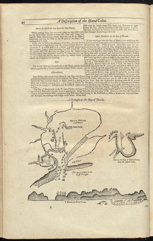
A draught of the Bay of Honda
Item Information
- Title:
- A draught of the Bay of Honda
- Date:
-
[1737]
- Format:
-
Maps/Atlases
- Location:
-
Boston Public Library
Norman B. Leventhal Map Center - Collection (local):
-
Norman B. Leventhal Map Center Collection
- Subjects:
-
Nautical charts--Cuba--Bahía Honda--Early works to 1800
Bahía de Cochinos (Cuba)--Maps--Early works to 1800
Bahía Honda (Cuba)--Maps--Early works to 1800
- Places:
-
Matanzas (province)Cochinos, Bahía de (bay)
Pinar del Río (province)Bahía Honda
- Extent:
- 1 map ; 22 x 24 cm., on sheet 46 x 29 cm.
- Terms of Use:
-
No known copyright restrictions.
No known restrictions on use.
- Publisher:
-
London :
Printed & sold by Page and Mount
- Scale:
-
Scale not given
- Language:
-
English
- Notes:
-
Depths shown by soundings.
Oriented with north to the bottom.
Inset: This is the Bay of Porto Porca, upon the island Cuba.
In the English pilot, the fourth book. London : Printed for William Mount and Thomas Page, 1737.
On p. 44 with text and a coastal profile.
On verso (p. 43): Text and coastal profiles.
- Notes (date):
-
This date is inferred.
- Identifier:
-
06_01_010277
- Call #:
-
G1106.P5 E54 1737
- Barcode:
-
30000003250869


