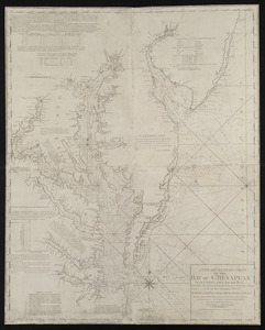
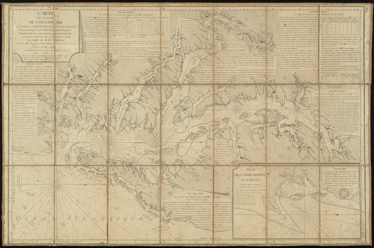
Carte de la baie de Chesapeake et de la partie navigable des rivières, James, York, Patowmack, Patuxen, Patapsco, North-East, Choptank et Pokomack
This map is also available in American Revolutionary Geographies Online (ARGO), a collections portal especially built for material relating to the American Revolutionary War Era. Visit ARGO to learn more about this item and explore the historical geography of North America in the late eighteenth century.
Item Information
- Title:
- Carte de la baie de Chesapeake et de la partie navigable des rivières, James, York, Patowmack, Patuxen, Patapsco, North-East, Choptank et Pokomack
- Creator:
- France. Dépôt des cartes et plans de la marine
- Name on Item:
-
redigée pour le service des vaisseaux du roi, au Dépôt général des cartes, plans et journaux de la marine, par ordre de M. de Sartine, conseiller d'Etat, Ministre et Secrétaire d'Etat au Département de la marine, d'après des plans anglois et particulierement ceux d'Antoine Smith, pilote de Ste. Marie ; Petit, sculp.
- Date:
-
1778
- Format:
-
Maps/Atlases
- Location:
-
Boston Public Library
Norman B. Leventhal Map Center - Collection (local):
-
Norman B. Leventhal Map Center Collection
- Subjects:
-
Nautical charts--Chesapeake Bay (Md. and Va.)--Early works to 1800
Chesapeake Bay (Md. and Va.)--Maps--Early works to 1800
- Places:
-
Chesapeake Bay
- Extent:
- 1 map ; 59 x 87 cm.
- Terms of Use:
-
No known copyright restrictions.
No known restrictions on use.
- Publisher:
-
Paris :
Dépôt general de la marine
- Scale:
-
Scale [ca. 1:420,000]
- Language:
-
French
- Notes:
-
Oriented with north to the right.
Depths shown by soundings.
Includes text.
Inset: Plan de la baie Herring en Maryland.
"14."
From the author's Neptune americo-septentrional (Paris, 1778-80).
Previously stored folded in a box as no. 3 in a set of 5 maps from the Neptune Americo-Septentrional.
- Identifier:
-
06_01_009979
- Call #:
-
G3842.C5P5 1778 .F73
- Barcode:
-
39999065667717
- LCCN:
-
73694810