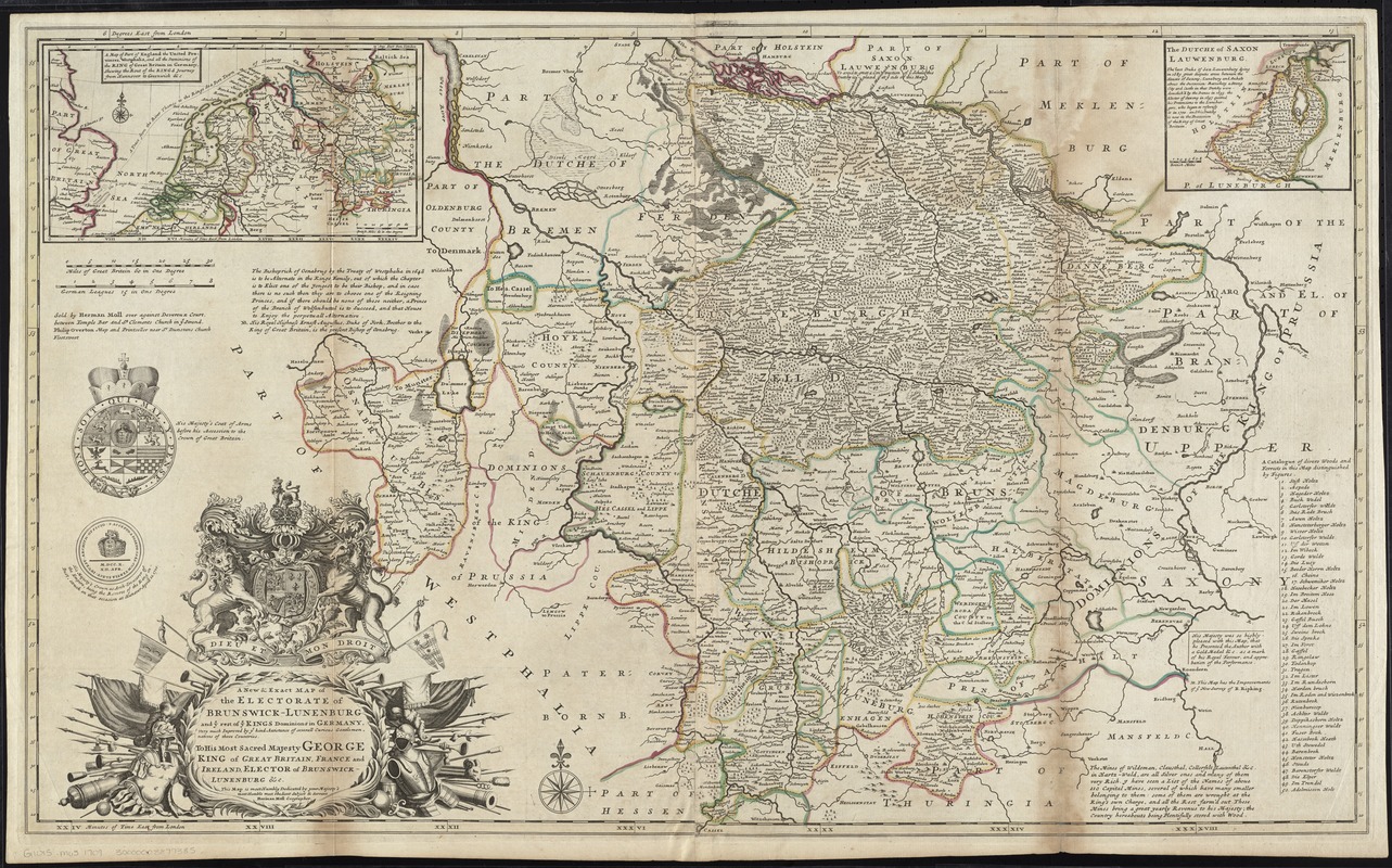
A new & exact map of the electorate of Brunswick-Lunenburg and ye rest of ye Kings dominions in Germany : very much improved by ye kind assistance of severall curious gentlemen, natives of those countries
Item Information
- Title:
- A new & exact map of the electorate of Brunswick-Lunenburg and ye rest of ye Kings dominions in Germany : very much improved by ye kind assistance of severall curious gentlemen, natives of those countries
- Creator:
- Moll, Herman, d. 1732
- Name on Item:
-
Herman Moll.
- Date:
-
[1730?]
- Format:
-
Maps/Atlases
- Location:
-
Boston Public Library
Norman B. Leventhal Map Center - Collection (local):
-
Norman B. Leventhal Map Center Collection
- Subjects:
-
Lower Saxony (Germany)--Maps--Early works to 1800
Braunschweig (Germany : State)--Maps--Early works to 1800
Lüneburg (Principality)--Maps--Early works to 1800
George I, King of Great Britain, 1660-1727
- Places:
-
Lower Saxony
- Extent:
- 1 map : hand col. ; 61 x 101 cm.
- Terms of Use:
-
No known copyright restrictions.
No known restrictions on use.
- Publisher:
-
[London] :
Sold by Herman Moll over against Devereux Court, between Temple Bar and St. Clements Church in ye Strand, Philip Overton Map and Printseller near St. Dunstans Church Fleetstreet
- Scale:
-
Scale [ca. 1:500,000]
- Language:
-
English
- Notes:
-
Relief shown pictorially.
Dedication: To his most sacred majesty George King of Great Britain, France and Ireland, Elector of Burnswick-Lunenburg &c. This map is most Humbly Dedicated by your Majesty's most Humble most Obedient Subject & Servant Herman Moll Geographer.
Insets: The Dutche of Saxon Lauwenburg -- A map of part of England, the United Provinces, Westphalia, and all the dominions of the King of Great Britain in Germany, shewing the rout of the Kings journey from Hannover to Greenwich &c.
Includes notes and key to forests indicated on the map.
Appears in Moll's The world described, [1709-1736], plate 21.
- Identifier:
-
06_01_009671
- Call #:
-
G1015 .M65 1709
- Barcode:
-
30000003777385
![Ducatus Brunsvicensis fere[que] Lunaeburgensis, cum adjacentibus Episcopatibus, Comit. Domin. etc., descriptio geographica](https://bpldcassets.blob.core.windows.net/derivatives/images/commonwealth:cj82kr74v/image_thumbnail_300.jpg)