A new map of Denmark and Sweden : according to ye newest and most exact observations
Item Information
- Title:
- A new map of Denmark and Sweden : according to ye newest and most exact observations
- Creator:
- Moll, Herman, d. 1732
- Name on Item:
-
by H: Moll Geographer.
- Date:
-
[1750?–1759?]
- Format:
-
Maps/Atlases
- Location:
-
Boston Public Library
Norman B. Leventhal Map Center - Collection (local):
-
Norman B. Leventhal Map Center Collection
- Subjects:
-
Scandinavia--Maps--Early works to 1800
Baltic States--Maps--Early works to 1800
- Places:
-
Baltic Countries (area)
Scandinavia (area)
- Extent:
- 1 map : hand col. ; 58 x 100 cm.
- Terms of Use:
-
No known copyright restrictions.
No known restrictions on use.
- Publisher:
-
[London] :
Printed for H. Moll ... Iohn Bowles & Son ... Thomas Bowles ... and by Philip Overton
- Scale:
-
Scale [ca. 1:2,800,000]
- Language:
-
English
- Notes:
-
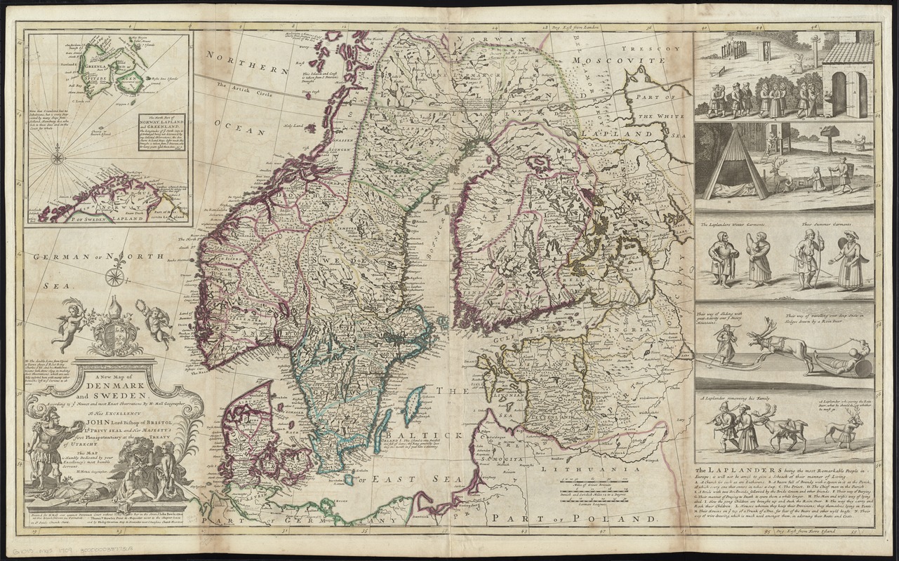
Relief shown pictorially.
Prime meridians: London and Ferro Island.
Dedication: To His Excellency John Lord Bishop of Bristol Ld. Privy Seal and Her Majesty's first Plenipotentiary at the Treaty of Utrecht. This map is Humbly Dedicated by your Excellency's most humble Servant. H: Moll Geographer.
Inset: The north part of Norway, Lapland and Greenland.
Includes notes and 5 vignettes pertaining to Laplanders.
Appears in Moll's The world described, [1709-1736], plate 14.
- Identifier:
-
06_01_009678
- Call #:
-
G1015 .M65 1709
- Barcode:
-
30000003877368

![Regni Sueciae tabula generalis, divisa in Sueciae, Gotiaeq[ue] regna Finniae ducatum Lapponiam, Livoniam Ingrianq[ue] et in omnes subiacentes provincias](https://bpldcassets.blob.core.windows.net/derivatives/images/commonwealth:cj82kt14t/image_thumbnail_300.jpg)


