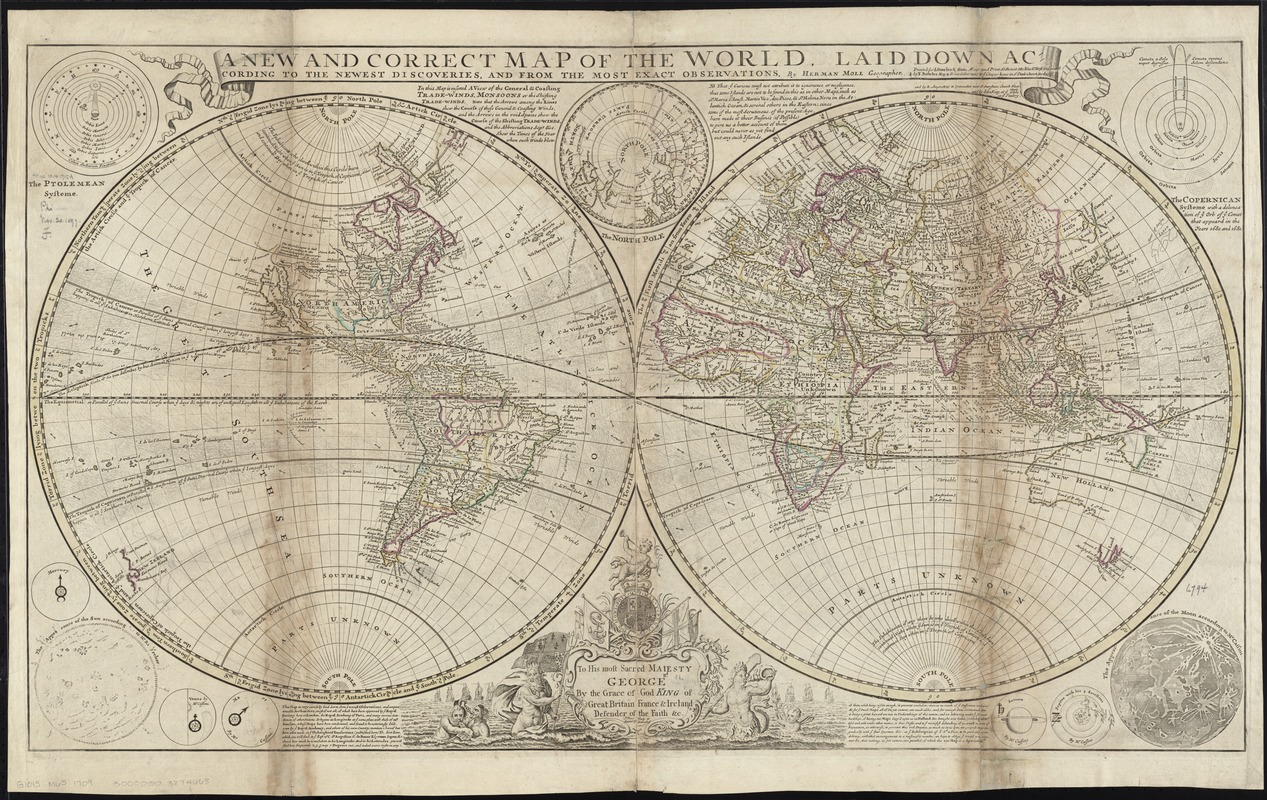
A new and correct map of the world, laid down according to the newest discoveries, and from the most exact observations
Item Information
- Title:
- A new and correct map of the world, laid down according to the newest discoveries, and from the most exact observations
- Creator:
- Moll, Herman, d. 1732
- Name on Item:
-
by Herman Moll, geographer.
- Date:
-
[1727?–1739?]
- Format:
-
Maps/Atlases
- Location:
-
Boston Public Library
Norman B. Leventhal Map Center - Collection (local):
-
Norman B. Leventhal Map Center Collection
- Subjects:
-
World maps--Early works to 1800
- Places:
-
World
- Extent:
- 1 map : hand col. ; 2 hemispheres each 47 cm. in diameter, in sheet 57 x 98 cm.
- Terms of Use:
-
No known copyright restrictions.
No known restrictions on use.
- Publisher:
-
[London] :
printed for L. Bowles & Son ... by T. Bowles ...and by R. Sayer ... and by John King
- Scale:
-
Scale [ca. 1:55,000,000] at equator ;
- Language:
-
English
- Notes:
-
Shows the world as a double hemisphere, annual winds and wind directions, solar equinox and ecliptic, and noted corrections over previous geography.
Prime meridian: Ferro.
Relief shown pictorially.
Insets: The Ptolemean systeme -- The North Pole -- The Copernican systeme -- Mercury -- The appearance of the Sun according to Mr. Kircher -- Venus -- Mars -- Saturn -- Jupiter -- The appearance of the Moon according to Mr. Cassini.
Includes dedication within ornamental cartouche: To His Most Sacred Majesty George IId by the grace of God King of Great Britain France & Ireland Defender of the Faith &c. this map is humbly dedicated.
Includes text.
Appears in Moll's The world described, [1709-1736], plate 1.
- Identifier:
-
06_01_009659
- Call #:
-
G1015 .M65 1709
- Barcode:
-
30000003874668


