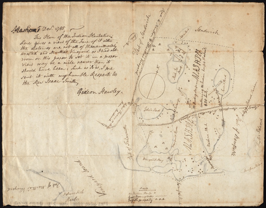
Plan of Mashpee
This map is also available in American Revolutionary Geographies Online (ARGO), a collections portal especially built for material relating to the American Revolutionary War Era. Visit ARGO to learn more about this item and explore the historical geography of North America in the late eighteenth century.
Item Information
- Title:
- Plan of Mashpee
- Title (alt.):
-
Plan of the indian plantations
- Description:
-
We Are One: This manuscript survey sketch provides an early example of the treaties between American leaders and native peoples that designated land for their use. Gideon Hawley, a Christian missionary to the Mashpee Indians, drew this reservation map for Reverend Isaac Smith in 1785. Like most Native American tribes in Massachusetts, the Mashpee lived on Cape Cod. The Mashpee fought with the Americans during the Revolutionary War and suffered heavy losses. In 1783, Hawley noted that there were at least 70 widows on the Mashpee reservation, most of whom had lost their husbands during the war.
- Creator:
- Hawley, Gideon, 1727-1807
- Date:
-
1785
- Format:
-
Maps/Atlases
Manuscripts
- Location:
-
Boston Public Library
Norman B. Leventhal Map Center - Collection (local):
-
Norman B. Leventhal Map Center Collection
- Subjects:
-
Mashpee Indians--Massachusetts--Maps
Mashpee (Mass.)--Maps
- Places:
-
Barnstable (county)Mashpee
- Extent:
- 1 ms. map ; 34 x 43 cm.
- Terms of Use:
-
No known copyright restrictions.
No known restrictions on use.
- Scale:
-
Scale [ca. 1:63,360]
- Language:
-
English
- Notes:
-
Title from verso. Alternate title from note.
Manuscript map of the Mashpee Indian lands on Cape Cod. Shows Indian houses, streams, and English property.
Oriented with north toward the upper right.
Includes ms. note: Mashpee [14?] Dec. 1785, This plan of the Indian Plantations here gives a view of the face of it altho the distances are not all of them accurately drafted and Martha's Vineyard as I had not enough room on this paper to set it in a proper view may be a mile nearer than it should have been. Such as it is, I [have?] sent it with my humble respects to the Rev. Isaac Smith. Gideon Hawley.
This map can be viewed as a georeferenced overlay in an interactive application made especially for We Are One: Mapping America's Road from Revolution to Independence http://d2o8owo4k087al.cloudfront.net/index.html?mapId=94.
- Notes (exhibitions):
-
Exhibited: "We Are One: Mapping America's Road from Revolution to Independence" organized by the Norman B. Leventhal Map Center at the Boston Public Library, 2015.
- Identifier:
-
06_01_009471
- Call #:
-
G3764.M378E1 1785 .H39x
- Barcode:
-
39999065662395


