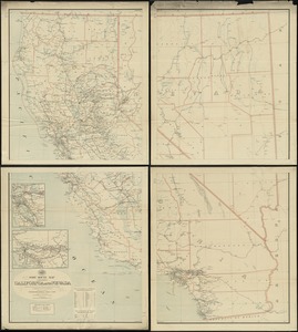
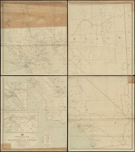
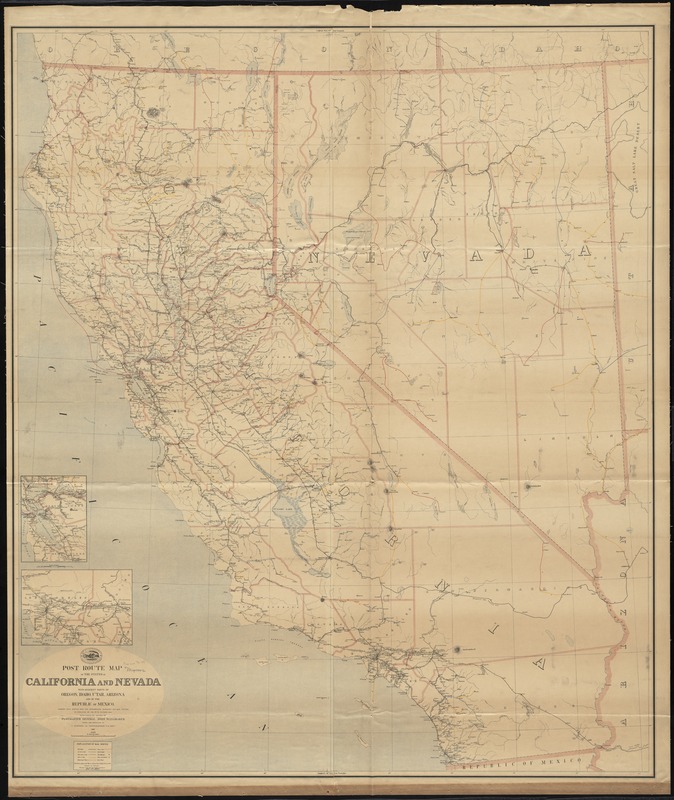
Post route map of the states of California and Nevada with adjacent parts of Oregon, Idaho, Utah, Arizona and of the Republic of Mexico : showing post offices with the intermediate distances and mail routes in operation on the 1st of October 1891
Item Information
- Title:
- Post route map of the states of California and Nevada with adjacent parts of Oregon, Idaho, Utah, Arizona and of the Republic of Mexico : showing post offices with the intermediate distances and mail routes in operation on the 1st of October 1891
- Creator:
- United States. Post Office Dept
- Name on Item:
-
published by order of Postmaster General John Wanamaker under the direction of C. Roeser Jr., Topographer, P.O. Dept.
- Date:
-
[1889]
- Format:
-
Maps/Atlases
- Location:
-
Boston Public Library
Norman B. Leventhal Map Center - Collection (local):
-
Norman B. Leventhal Map Center Collection
- Subjects:
-
Counties--California--Maps
Counties--Nevada--Maps
Railroads--California--Maps
Railroads--Nevada--Maps
Postal service--California--Maps
Postal service--Nevada--Maps
California--Maps
Nevada--Maps
- Places:
-
California
Nevada
- Extent:
- 1 map on 4 sheets : col., assembled ; 145 x 124 cm.
- Terms of Use:
-
No known copyright restrictions.
No known restrictions on use.
- Publisher:
-
[Washington?] :
The Dept.
- Scale:
-
Scale [ca. 1:750,000]
- Language:
-
English
- Notes:
-
Also shows counties and railroads.
Prime meridians: Washington, D.C. and Greenwich.
Relief shown by hachures.
Insets: [San Francisco and vicinity] -- [Los Angeles and vicinity].
- Notes (date):
-
This date is inferred.
- Identifier:
-
06_01_008976
- Call #:
-
G4361.P8 1891 .U55x
- Barcode:
-
39999065658443