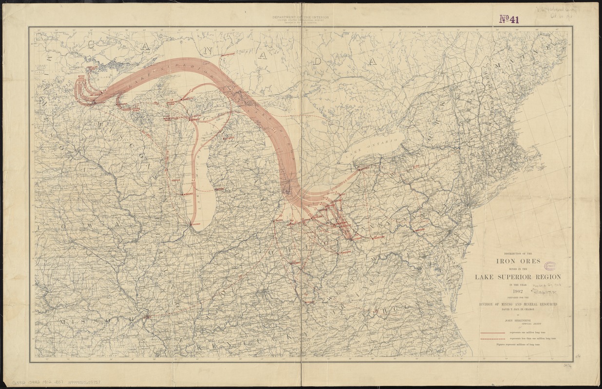
Distribution of the iron ores mined in the Lake Superior Region in the year 1902
Item Information
- Title:
- Distribution of the iron ores mined in the Lake Superior Region in the year 1902
- Description:
-
America Transformed: This map depicts the geography of the iron and steel industry during the last half of the 19th century when coke from coal was introduced into the manufacturing process. Consequently, iron and steel factories moved closer to the coal sources, since coal was bulkier and more expensive to transport than iron ore. This map uses flow lines, a graphic statistical device innovative for the time, with the width of the lines representing the tonnage of iron coming from Michigan's Upper Peninsula and northeastern Minnesota and shipped to ports in the lower Great Lakes, including Chicago, Toledo, Cleveland, Erie, Buffalo, and Pittsburgh.
- Creator:
- Birkinbine, John, 1844-1915
- Name on Item:
-
prepared for the Division of Mining and Mineral Resources by John Birkinbine, Special Agent ; Department of the Interior, United States Geological Survey.
- Date:
-
1902
- Format:
-
Maps/Atlases
- Location:
-
Boston Public Library
Norman B. Leventhal Map Center - Collection (local):
-
Norman B. Leventhal Map Center Collection
- Subjects:
-
Iron ores--Great Lakes Region (North America)--Maps
Iron industry and trade--Great Lakes Region (North America)--Maps
Iron ores--Transportation--Superior, Lake--Maps
Shipping--Great Lakes (North America)--Maps
Great Lakes Region (North America)--Maps
- Places:
-
Great Lakes Region (area)
Superior, Lake
- Extent:
- 1 map : col. ; 54 x 89 cm.
- Terms of Use:
-
No known copyright restrictions.
No known restrictions on use.
- Publisher:
-
[Washington, D.C.] :
United States Geological Survey
- Scale:
-
Scale [ca. 1:2,500,000]
- Language:
-
English
- Notes:
-
Shows iron ore shipping routes in red.
- Notes (exhibitions):
-
Exhibited: "America Transformed. Part 2: Homesteads to Modern Cities," organized by the Norman B. Leventhal Map & Education Center at the Boston Public Library, 2019-2020.
- Identifier:
-
06_01_008632
- Call #:
-
G3312.S9H2 1902 .B57
- Barcode:
-
39999065655753