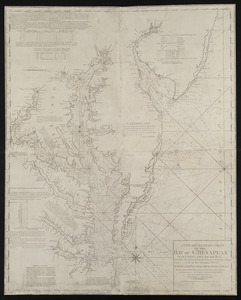
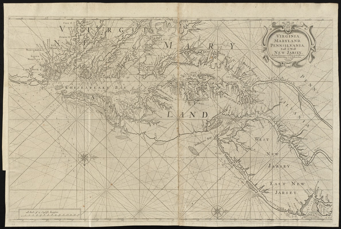
Virginia, Maryland, Pennsilvania, east & west New Jarsey
Item Information
- Title:
- Virginia, Maryland, Pennsilvania, east & west New Jarsey
- Title (alt.):
-
Virginia, Maryland, Pennsylvania, east and west New Jersey
Collection of old maps
- Creator:
- Thornton, John, fl. 1652-1701
- Name on Item:
-
by John Thornton ... and by Will: Fisher.
- Date:
-
[1706]
- Format:
-
Maps/Atlases
- Location:
-
Boston Public Library
Norman B. Leventhal Map Center - Collection (local):
-
Norman B. Leventhal Map Center Collection
- Subjects:
-
Nautical charts--Middle Atlantic States--Early works to 1800
Nautical charts--Virginia--Early works to 1800
Nautical charts--Atlantic Coast (U.S.)--Early works to 1800
Nautical charts--Delaware Bay (Del. and N.J.)--Early works to 1800
Nautical charts--Delaware River Estuary (N.Y.-Del. and N.J.)--Early works to 1800
Nautical charts--Chesapeake Bay (Md. and Va.)--Early works to 1800
Nautical charts--New York Bight (N.J. and N.Y.)--Early works to 1800
Middle Atlantic States--Maps--Early works to 1800
Virginia--Maps--Early works to 1800
Atlantic Coast (U.S.)--Maps--Early works to 1800
Delaware River Estuary--Maps--Early works to 1800
Delaware Bay (Del. and N.J.)--Maps--Early works to 1800
Chesapeake Bay (Md. and Va.)--Maps--Early works to 1800
New York Bight (N.J. and N.Y.)--Maps--Early works to 1800
- Places:
-
Delaware River
Delaware Bay
Virginia
Chesapeake Bay
- Extent:
- 1 map ; 51 x 81 cm.
- Terms of Use:
-
No known copyright restrictions.
No known restrictions on use.
- Publisher:
-
London :
John Thornton at ye Platt in the Minories and by Will: Fisher at ye Postorn Gate on Tower hill, London
- Edition:
- 4th state.
- Scale:
-
Scale [ca. 1:590,000]
- Language:
-
English
- Notes:
-
Nautical chart of the coast from New York Bay to Chesapeake Bay, with two compass roses and a cartouche in upper right corner. Scale in English leagues.
Depths shown by soundings and stippling; selected relief shown pictorially.
Oriented with north to the right.
From: The English pilot. The fourth book.
State 4 according to Burden.
Soundings are added between Cape Charles and the nearest compass rose.
Engraved on two plates.
Cataloging, conservation, and digitization made possible in part by The National Endowment for the Humanities: Exploring the human endeavor.
Part of composite portfolio atlas with title "Collection of old maps."
- Notes (date):
-
This date is inferred.
- Identifier:
-
06_01_010221
- Call #:
-
G1015 .C651 1630
- Barcode:
-
30000003235154