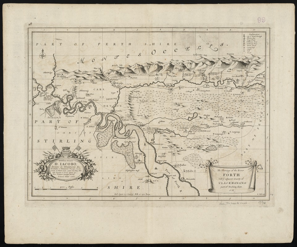
The turnings of the River Forth with ye adjacent County of Clackmanan & part of Stirling shire
Item Information
- Title:
- The turnings of the River Forth with ye adjacent County of Clackmanan & part of Stirling shire
- Title (alt.):
-
Turnings of the River Forth with ye adjacent County of Clackmanan and part of Stirling shire
- Creator:
- Adair, John, 1660-1718
- Name on Item:
-
H. Moll, sculp.
- Date:
-
1688
- Format:
-
Maps/Atlases
- Location:
-
Boston Public Library
Norman B. Leventhal Map Center - Collection (local):
-
Norman B. Leventhal Map Center Collection
- Subjects:
-
Clackmannanshire (Scotland)--Maps--Early works to 1800
Scotland--Maps--Early works to 1800
- Places:
-
ScotlandClackmannanshire (county)
- Extent:
- 1 map ; 36 x 51 cm.
- Terms of Use:
-
No known copyright restrictions.
No known restrictions on use.
- Publisher:
-
Scotland? :
[s.n.]
- Scale:
-
Scale [ca. 1:88,700]
- Language:
-
English
- Notes:
-
Shows the course of the River Forth with the adjacent area, i.e. Clackmannanshire and part of Stirlingshire and Perthshire.
Relief shown pictorially.
Shows gridlines, settlements, selected buildings, enclosures, roads, rivers and tributaries, woods, vegetation.
Scale statement reads, "4000 Passus", with scale bar graded 0-4.
Includes legend (top right corner).
At bottom of map "Each Squair is a Countrey Mille or 1500 Passus."
On bottom left hand corner: oval cartouche decorated with coat of arms, flags and a festoon of foliage and fruits, containing a dedication in Latin to D. Iacobo from Ioannes Adair, author.
Beside the title cartouche "H. Moll, Sculp."
Originally included in the "Atlas" of Joannis de Ram. First published in 1688.
Cataloging, conservation, and digitization made possible in part by The National Endowment for the Humanities: Exploring the human endeavor.
Part of composite portfolio atlas with title "Collection of old maps."
- Identifier:
-
06_01_010011
- Call #:
-
G1015 .C651 1630
- Barcode:
-
30000003115227


![Exactissima Regni Scotiae tabula tam in septentrionalem et meriodionalem quam in minores earundem provincias, insulasq[ue] ei undique praetensas accurate divisa](https://bpldcassets.blob.core.windows.net/derivatives/images/commonwealth:cj82kz35d/image_thumbnail_300.jpg)
