Spherical projection world
Item Information
- Title:
- Spherical projection world
- Description:
-
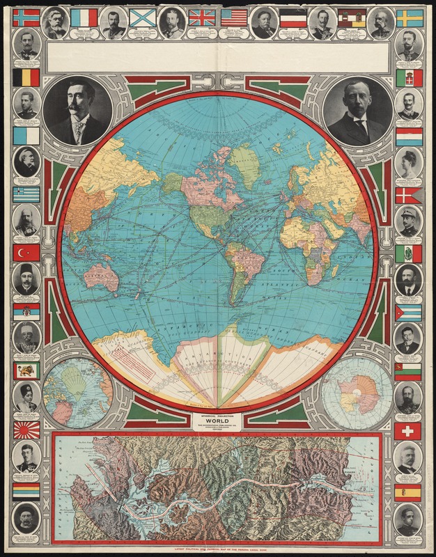
Borders, political dominance, and colonial rule: these were headline news one hundred years ago just as they are today. Blatantly imperialistic, this map was made during the political tensions before World War I to declare world powers’ land claims. In the "Spherical Projection World" map, global dominance is asserted with the images of international leaders and their flags. Explorers and commentary on polar discovery are also included, indicating there were new territories yet to be conquered.
- Creator:
- Geographical Publishing Co
- Date:
-
[1913]
- Format:
-
Maps/Atlases
- Location:
-
Boston Public Library
Norman B. Leventhal Map Center - Collection (local):
-
Norman B. Leventhal Map Center Collection
- Subjects:
-
World maps
Panama Canal (Panama)--Maps
- Places:
-
Panama Canal
World
- Extent:
- 1 map : col. ; 52 cm. in diameter, on sheet 90 x 70 cm.
- Terms of Use:
-
No known copyright restrictions.
No known restrictions on use.
- Publisher:
-
Vancouver, B.C :
News-Advertiser
- Scale:
-
Scale [ca. 1:76,000,000]
- Language:
-
English
- Notes:
-
Ancillary maps: Arctic regions -- Antarctic regions -- Latest political and physical map of the Panama Canal Zone.
Includes portraits of Arctic explorers and world leaders.
Text, illustrations, and chart on verso.
Bound with metal clip on top edge and issued with 2 maps: British Columbia -- Dominion of Canada/Intermediate series United States
- Notes (date):
-
This date is inferred.
- Notes (exhibitions):
-
Exhibited: "Crossing Boundaries: Art // Maps" organized by the Norman B. Leventhal Map & Education Center at the Boston Public Library, 2018-2019.
- Identifier:
-
06_01_008426
- Call #:
-
G3510 1913 .N49x
- Barcode:
-
39999065653857


