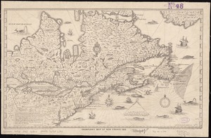
Il disegno del discoperto della noua Franza : ilquale s'è hauuto ultimamente dalla nouissima nauigatione dè Franzesi in quel luogo: nel quale si uedono tutti l'Isole, Porti, Capi, et luoghi fra terra chein quella sono
Item Information
- Title:
- Il disegno del discoperto della noua Franza : ilquale s'è hauuto ultimamente dalla nouissima nauigatione dè Franzesi in quel luogo: nel quale si uedono tutti l'Isole, Porti, Capi, et luoghi fra terra chein quella sono
- Title (alt.):
-
Disegno del discoperto della noua Franza
- Creator:
- Forlani, Paolo.
- Name on Item:
-
Bolognini Zalterii.
- Date:
-
[1892]
- Format:
-
Maps/Atlases
- Location:
-
Boston Public Library
Norman B. Leventhal Map Center - Collection (local):
-
Norman B. Leventhal Map Center Collection
- Subjects:
-
Northwest Passage
North America--Maps--Early works to 1800--Facsimiles
- Places:
-
North America (area)
Northwest Passage
- Extent:
- 1 map ; 27 x 39 cm.
- Terms of Use:
-
No known copyright restrictions.
No known restrictions on use.
- Publisher:
-
Washington, D.C :
Library of Congress
- Scale:
-
Scale not given
- Language:
-
Italian
- Notes:
-
Facsimile published by the Library of Congress to mark the 400th anniversary of Columbus' discovery of America. Matches neither original state as some islands of the Azores, Canaries, and Cape Verde are joined.
Relief shown pictorially.
The plate for this map was purchased by Zaltieri in late 1565 or early 1566. He issued the map in 1566 with "Venetijs æneis formis Bolognini Zalterij Anno M.D. LXVI" added below the title.
One of the earliest maps to depict and name the Strait of Anian.
Originally published: Venice : Bolognino Zaltieri, 1566.
- Notes (date):
-
This date is inferred.
- Identifier:
-
06_01_008402
- Call #:
-
G3300 1566 .F57x 1892
- Barcode:
-
39999065653691