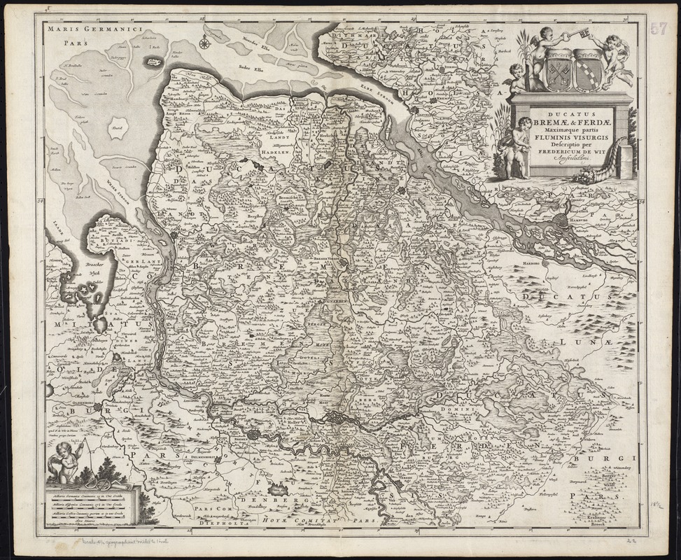
Ducatus Bremae & Ferdae maximaque partis fluminis Visurgis descriptio
Item Information
- Title:
- Ducatus Bremae & Ferdae maximaque partis fluminis Visurgis descriptio
- Title (alt.):
-
Ducatus Bremae et Ferdae maximaque partis fluminis Visurgis descriptio
Collection of old maps
- Creator:
- Wit, Frederik de.
- Name on Item:
-
per Fredericum de Wit.
- Date:
-
[1680?]
- Format:
-
Maps/Atlases
- Location:
-
Boston Public Library
Norman B. Leventhal Map Center - Collection (local):
-
Norman B. Leventhal Map Center Collection
- Subjects:
-
Lower Saxony (Germany)--Maps--Early works to 1800
- Places:
-
Lower Saxony
- Extent:
- 1 map ; 48 x 56 cm.
- Terms of Use:
-
No known copyright restrictions.
No known restrictions on use.
- Publisher:
-
Amstelodami :
[Frederik de Wit]
- Scale:
-
Scale [ca. 1:320,000]
- Language:
-
Latin
- Notes:
-
Map of the historical Duchies of Bremen and Verden in present day Lower Saxony, Germany.
Relief shown pictorially.
Prime meridian: Ferro.
Bar scales given in "milliaria Germanica communia," "milliaria Hispanica communia," and "milliaria Gallica communia".
Appears in various editions of Wit's Atlas.
In Latin.
Cataloging, conservation, and digitization made possible in part by The National Endowment for the Humanities: Exploring the human endeavor.
Part of composite portfolio atlas with title "Collection of old maps."
- Identifier:
-
06_01_009946
- Call #:
-
G1015 .C651 1630
- Barcode:
-
30000003914068
![Ducatus Brunsvicensis fere[que] Lunaeburgensis, cum adjacentibus Episcopatibus, Comit. Domin. etc., descriptio geographica](https://bpldcassets.blob.core.windows.net/derivatives/images/commonwealth:cj82kr74v/image_thumbnail_300.jpg)