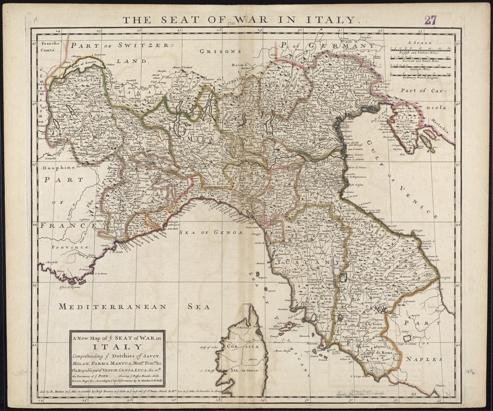
A new map of ye seat of war in Italy : comprehending ye Dutchies of Savoy, Milan, Parma Mantua, Modna., Tuscny., &c. : the Republiques of Venice, Genoa, Luca, &c. wth., the territories of ye Pope : shewing ye passes, roads, hills, rivers, bogs, &c. according to ye late observations
Item Information
- Title:
- A new map of ye seat of war in Italy : comprehending ye Dutchies of Savoy, Milan, Parma Mantua, Modna., Tuscny., &c. : the Republiques of Venice, Genoa, Luca, &c. wth., the territories of ye Pope : shewing ye passes, roads, hills, rivers, bogs, &c. according to ye late observations
- Title (alt.):
-
Seat of war in Italy
Collection of old maps
- Description:
-
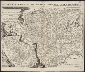
Ann Lea took over her deceased husband Philip’s business in 1701, and for the next twenty-five years managed the firm with various partners, including Robert Morden, Christopher Browne, William Berry and her son-in-law Richard Glynne. She published the map displayed here with Morden and Browne while she was in business “at the sign of Atlas and Hercules” in Cheapside, London. Part of a composite atlas, this map reflects the region of northern Italy with various duchies, or dukedoms, fought over and exchanged under the rule of France, Switzerland and the Habsburgs, until Italy evolved into a unified nation extending from the Alps to the Mediterranean.
Ann Lea took over her deceased husband Philip's business in 1701, and for the next twenty-five years managed the firm with various partners, including Robert Morden, Christopher Browne, William Berry and her son-in-law Richard Glynne. She published the map displayed here with Morden and Browne while she was in business "at the sign of Atlas and Hercules" in Cheapside, London. Part of a composite atlas, this map reflects the region of northern Italy with various duchies, or dukedoms, fought over and exchanged under the rule of France, Switzerland and the Habsburgs, until Italy evolved into a unified nation extending from the Alps to the Mediterranean.
- Creator:
- Morden, Robert, d. 1703
- Name on Item:
-
by R. Morden & H. Moll.
- Date:
-
[1701]
- Format:
-
Maps/Atlases
- Location:
-
Boston Public Library
Norman B. Leventhal Map Center - Collection (local):
-
Norman B. Leventhal Map Center Collection
- Subjects:
-
Spanish Succession, War of, 1701-1714--Maps--Early works to 1800
Italy--Maps--Early works to 1800
Italy, Northern--Maps--Early works to 1800
- Places:
-
Italy
- Extent:
- 1 map : hand col. ; 47 x 54 cm.
- Terms of Use:
-
No known copyright restrictions.
No known restrictions on use.
- Publisher:
-
[London] :
Sold by R. Morden at ye Atlas in Cornhill, by Christ. Browne at ye Globe at ye West end of St. Paules Church, & Mris. Lea at ye Atlas & Hercules in Cheap side
- Scale:
-
Scale [ca. 1:1,450,000]
- Language:
-
English
- Notes:
-
Map of Italian lands involved in the War of the Spanish Succession, 1701-1714.
Relief shown pictorially.
Cataloging, conservation, and digitization made possible in part by The National Endowment for the Humanities: Exploring the human endeavor.
Part of composite portfolio atlas with title "Collection of old maps."
- Notes (date):
-
This date is inferred.
- Notes (exhibitions):
-
Exhibited: "Women in Cartography: Five Centuries of Accomplishments" organized by the Norman B. Leventhal Map Center at the Boston Public Library, 2015-2016.
- Identifier:
-
06_01_009661
- Call #:
-
G1015 .C651 1630
- Barcode:
-
30000003876436