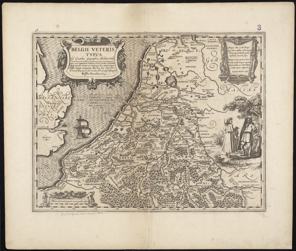
Belgii veteris typus
Item Information
- Title:
- Belgii veteris typus
- Title (alt.):
-
Collection of old maps
- Creator:
- Ortelius, Abraham, 1527-1598
- Name on Item:
-
ex conatibus geographicis Abrahami Ortelii.
- Date:
-
1624
- Format:
-
Maps/Atlases
- Location:
-
Boston Public Library
Norman B. Leventhal Map Center - Collection (local):
-
Norman B. Leventhal Map Center Collection
- Subjects:
-
Benelux countries--Maps--Early works to 1800
- Places:
-
Low Countries (area)
- Extent:
- 1 map ; 36 x 48 cm.
- Terms of Use:
-
No known copyright restrictions.
No known restrictions on use.
- Publisher:
-
[Amsterdam?] :
C.J. Visscher excudebat
- Scale:
-
Scale [ca. 1:1,460,000]
- Language:
-
Latin
- Notes:
-
Map of the Netherlands and Belgium.
Relief shown pictorially.
Title in decorative cartouche.
Text in cartouche by Ludovicus Hondius Lusit describing the ancient region of Belgium.
Includes ill.
Cataloging, conservation, and digitization made possible in part by The National Endowment for the Humanities: Exploring the human endeavor.
Part of composite portfolio atlas with title "Collection of old maps."
- Identifier:
-
06_01_009528
- Call #:
-
G1015 .C651 1630
- Barcode:
-
30000003862865