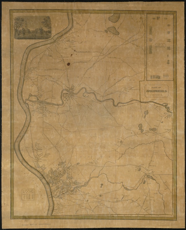
Plan of Springfield
Item Information
- Title:
- Plan of Springfield
- Creator:
- Colton, Geo.
- Engraver:
- O'Brien, R.
- Name on Item:
-
by Geo. Colton.
- Date:
-
1835
- Format:
-
Maps/Atlases
- Location:
-
Boston Public Library
Norman B. Leventhal Map Center - Collection (local):
-
Norman B. Leventhal Map Center Collection
- Subjects:
-
Real property--Massachusetts--Springfield--Maps
Landowners--Massachusetts--Springfield--Maps
Real property--Massachusetts--Chicopee--Maps
Landowners--Massachusetts--Chicopee--Maps
Springfield (Mass.)--Maps
Chicopee (Mass.)--Maps
Springfield (Mass.)--Administrative and political divisions--Maps
Chicopee (Mass.)--Administrative and political divisions--Maps
- Places:
-
Hampden (county)Chicopee
Hampden (county)Springfield
- Extent:
- 1 map : hand col. ; 77 x 61 cm.
- Terms of Use:
-
No known copyright restrictions.
No known restrictions on use.
- Publisher:
-
New York? :
[Geo. Colton]
- Scale:
-
Scale [ca. 1:19,008].
- Language:
-
English
- Notes:
-
Partial cadastral map with names of landowners, districts numbered and colored.
Covers the City of Springfield and the Town of Chicopee, Massachusetts.
Includes engraving by R. O'Brien from a sketch by Elwell.
Population chart in lower left corner with text: First settled May 25 1636. Burnt by the Indians in Phillips War Oct. 16, 1675.
Inset: Plan of Franklin Square.
Plan of Franklin Square shows points of interest.
- Identifier:
-
06_01_007660
- Call #:
-
G3764.S7 1835 .C65
- Barcode:
-
39999059032597