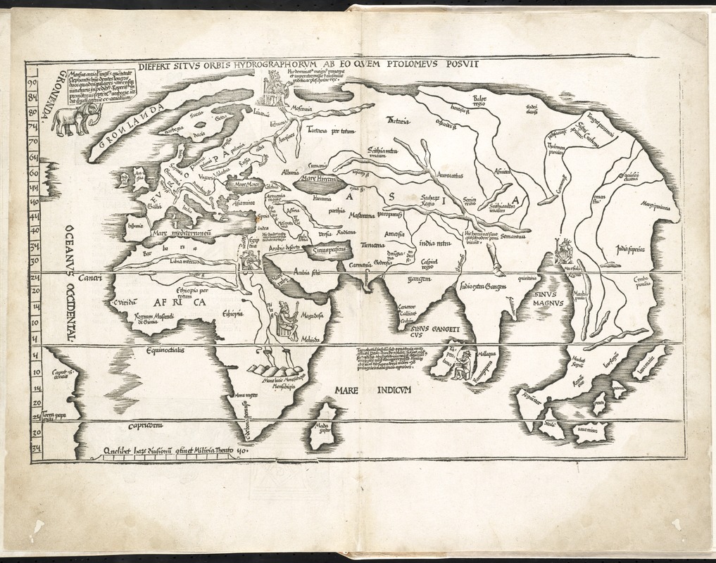
Tabula moder. Gronlandiae et Russiae
Item Information
- Title:
- Tabula moder. Gronlandiae et Russiae
- Title (alt.):
-
Tabula moderna Gronlandiae et Russiae
Diefert situs orbis hydrographorum ab eo quem Ptolomeus posuit
- Creator:
- Fries, Lorenz, ca. 1490-1531
- Date:
-
1525
- Format:
-
Maps/Atlases
- Location:
-
Boston Public Library
Norman B. Leventhal Map Center - Collection (local):
-
Norman B. Leventhal Map Center Collection
- Subjects:
-
Eastern Hemisphere--Maps--Early works to 1800
- Places:
-
Europe
Asia
Africa
Oceania
Europe
Africa
Asia
Oceania
- Extent:
- 1 map ; 28 x 44 cm.
- Terms of Use:
-
No known copyright restrictions.
No known restrictions on use.
- Publisher:
-
Argentoragi [i.e. Strasbourg] :
Iohannes Grieningerus
- Scale:
-
Scale [ca. 1:50,000,000]
- Language:
-
Latin
- Notes:
-
Map of the eastern hemisphere showing Europe, Asia, and Africa.
Reduced version of the corresponding map in Waldseemüller's atlas of 1513.
Relief shown pictorially.
Includes names of places and natural features.
Appears in the author's Geographia, translated by Willibald Pirckheimer, with annotations by Joannes Regiomontanus. Argentoragi [i.e. Strasbourg] : Iohannes Grieningerus, communibus Iohannis Koberger impensis excudebat, anno a Christi Natiuitate 1525 tertio Kal[endas] Apriles.
Text in Latin.
Cataloging, conservation, and digitization made possible in part by The National Endowment for the Humanities: Exploring the human endeavor.
Atlas scanned by Internet Archive http://archive.org/details/claudiiptolemaei00ptol
- Identifier:
-
06_01_008020
- Call #:
-
G1005 .P7 1525
- Barcode:
-
30000003788993