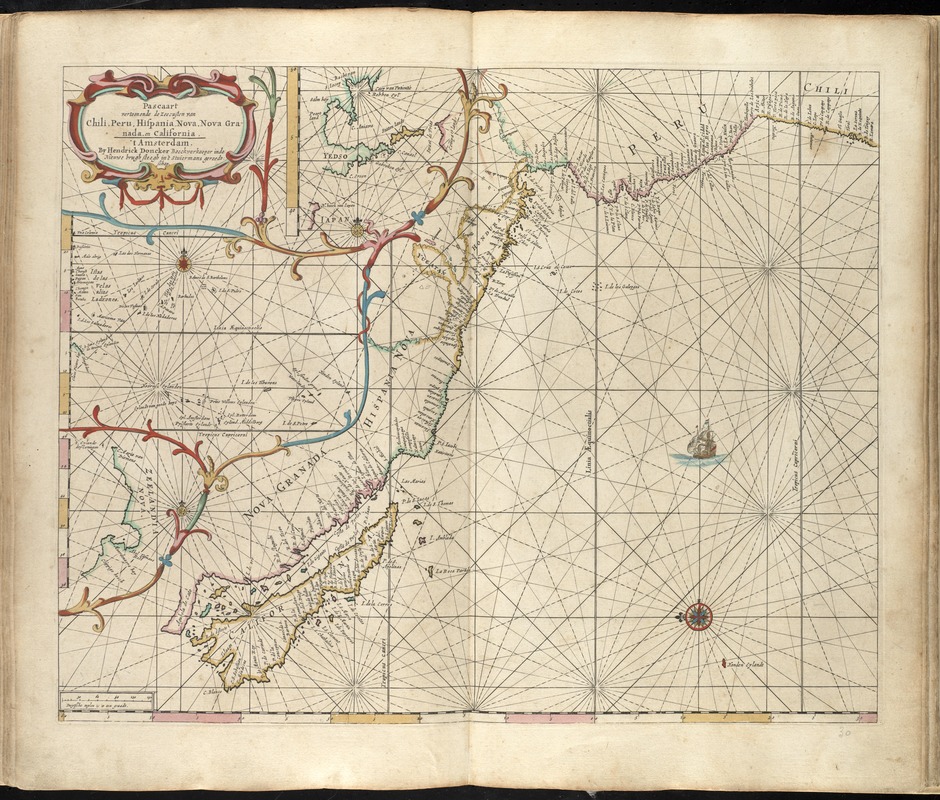
Pascaart vertoonende de zeecusten van Chili, Peru, Hispania Nova, Nova Granada en California
Item Information
- Title:
- Pascaart vertoonende de zeecusten van Chili, Peru, Hispania Nova, Nova Granada en California
- Creator:
- Doncker, Hendrick, 1626-1699
- Name on Item:
-
by Hendrick Doncker.
- Date:
-
[1660]
- Format:
-
Maps/Atlases
- Location:
-
Boston Public Library
Norman B. Leventhal Map Center - Collection (local):
-
Norman B. Leventhal Map Center Collection
- Subjects:
-
Pacific Coast (South America)--Maps--Early works to 1800
Pacific Coast (Central America)--Maps--Early works to 1800
Pacific Coast (Calif.)--Maps--Early works to 1800
- Places:
-
Mesoamerica (area)
South America
South America
- Extent:
- 1 map : hand col. ; 43 x 54 cm.
- Terms of Use:
-
No known copyright restrictions.
No known restrictions on use.
- Publisher:
-
Amsterdam :
By Hendrik Doncker, boeckverkooper, en graat-boog-maker, in de Nieuwe-brug-steegh, in 't Stuurmans Gereetschap
- Scale:
-
Scale ca. 1:9,000,000.
- Language:
-
Dutch
- Notes:
-
Map of the Pacific coast of California, Central America, and South America.
California is depicted as an island.
Appears in the author's Zee-atlas of Water-waerelt. Amsetrdam : Hendrick Doncker, Anno 1660 [i.e. 1665].
Cataloging, conservation, and digitization made possible in part by The National Endowment for the Humanities: Exploring the human endeavor.
Atlas scanned by Internet Archive http://archive.org/details/dezeeatlasofwate00donc
- Notes (date):
-
This date is inferred.
- Identifier:
-
06_01_007875
- Call #:
-
G1059 .D66 1665
- Barcode:
-
30000003765655