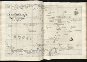
[Alleen de Caribische Eilanden, vervat in 't groot]
![[Alleen de Caribische Eilanden, vervat in 't groot]](https://bpldcassets.blob.core.windows.net/derivatives/images/commonwealth:st74cw59p/image_access_800.jpg)
Item Information
- Title:
- [Alleen de Caribische Eilanden, vervat in 't groot]
- Creator:
- Doncker, Hendrick, 1626-1699
- Name on Item:
-
bij Hendrick Doncker boeckverkooper en graadbooghmaeker, inde nieuwbrughsteech in 't stuurmans gereedtschap. Anno 1658.
- Date:
-
[1660]
- Format:
-
Maps/Atlases
- Location:
-
Boston Public Library
Norman B. Leventhal Map Center - Collection (local):
-
Norman B. Leventhal Map Center Collection
- Subjects:
-
Antilles, Greater--Maps--Early works to 1800
Antilles, Lesser--Maps--Early works to 1800
West Indies--Maps--Early works to 1800
- Places:
-
Greater Antilles (area)
Lesser Antilles (area)
West Indies
- Extent:
- 1 map : col. ; 55 x 44 cm.
- Terms of Use:
-
No known copyright restrictions.
No known restrictions on use.
- Publisher:
-
Amsterdam :
By Hendrik Doncker, boeckverkooper, en graat-boog-maker, in de Nieuwe-brug-steegh, in 't Stuurmans Gereetschap
- Scale:
-
Scale [ca. 1:2,050,000].
- Language:
-
Dutch
- Notes:
-
Map of the Caribbean Sea, Puerto Rico, the Lesser Antilles, northern Venezuela and Trinidad and Tobago.
Relief shown by soundings for western coast of Trinidad and Tobago.
Map oriented with north to right.
Title from bibliography in: Atlantes Neerlandici / compiled and edited by Ir. C. Koeman. Amsterdam : Theatrum Orbis Terrarum, 1970. vol. 4, p. 158.
From the author's De zee-atlas ofte water-waereld. Amsterdam: By Hendrik Doncker, boeckverkooper, en graat-boog-maker, in de Nieuwe-brug-steegh, in 't Stuurmans Gereetschap, Anno 1660 [i.e. 1665].
Cataloging, conservation, and digitization made possible in part by The National Endowment for the Humanities: Exploring the human endeavor.
Atlas scanned by Internet Archive http://archive.org/details/dezeeatlasofwate00donc
- Notes (date):
-
This date is inferred.
- Identifier:
-
06_01_007871
- Call #:
-
G1059 .D66 1665
- Barcode:
-
30000003764965