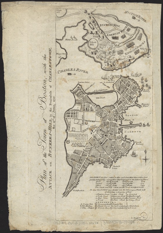
Plan of the town of Boston, with the attack on Bunkers-Hill, in the peninsula of Charlestown, the 17th of June, 1775
This map is also available in American Revolutionary Geographies Online (ARGO), a collections portal especially built for material relating to the American Revolutionary War Era. Visit ARGO to learn more about this item and explore the historical geography of North America in the late eighteenth century.
Item Information
- Title:
- Plan of the town of Boston, with the attack on Bunkers-Hill, in the peninsula of Charlestown, the 17th of June, 1775
- Creator:
- Norman, John, 1748?-1817
- Name on Item:
-
J. Norman sc.
- Date:
-
[1781]
- Format:
-
Maps/Atlases
- Location:
-
Boston Public Library
Norman B. Leventhal Map Center - Collection (local):
-
Norman B. Leventhal Map Center Collection
- Subjects:
-
Bunker Hill, Battle of, Boston, Mass., 1775--Maps--Early works to 1800
Maps
Boston (Mass.)--History--Revolution, 1775-1783--Maps--Early works to 1800
Charlestown (Mass.) Boston (Mass.)--History--Revolution, 1775-1783--Maps--Early works to 1800
United States--History--Revolution, 1775-1783--Maps--Early works to 1800
- Places:
-
Suffolk (county)BostonBunker Hill
Suffolk (county)BostonCharlestown
- Extent:
- 1 map ; 29 x 14 cm, on sheet 31 x 22 cm.
- Terms of Use:
-
No known copyright restrictions.
No known restrictions on use.
- Publisher:
-
Boston :
s.n.
- Scale:
-
Scale ca. 1:15,840.
- Language:
-
English
- Notes:
-
Appears in James Murray's Boston edition of An Impartial History of the War in America (Boston: For Nathaniel Coverly and Robert Hodge, 1781-84).
Derived directly from a map in the English edition of Murray's An Impartial History of the War in America.
Charlestown shown in flames.
Table of references identifies fires, wards, and places of interest.
- Notes (date):
-
This date is inferred.
- Identifier:
-
06_01_007827
- Call #:
-
G3764.B6S3 1781 .N67x
- Barcode:
-
39999065649459


