Leavitt's map with views of the White Mountains, New Hampshire : 1871
Item Information
- Title:
- Leavitt's map with views of the White Mountains, New Hampshire : 1871
- Description:
-
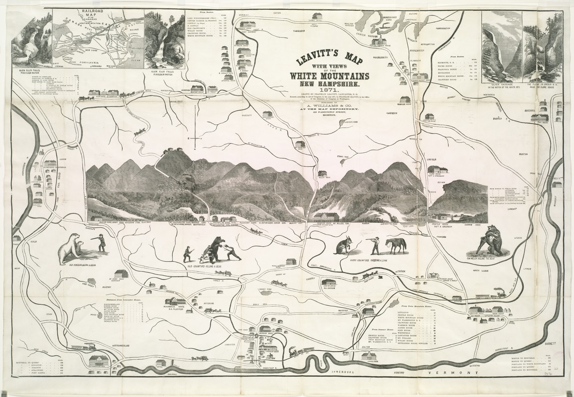
Combining folk art with a schematic tourist map, this unusual map views the White Mountains from the northwest. In the center, the mountains were drawn in landscape format surrounded by curious vignettes including “Old Crawford Killing a Bear” and “Harry Crawford Killing a Lynx”. Along the top are a railroad map and views of waterfalls, while symbolic images of hotels, stage coaches, and trains alert readers to the region’s tourist amenities. Leavitt, a laborer, mountain guide, and self-taught mapmaker, created this pictorial map. Reflecting his regional bias, he located Lancaster, his hometown, and the Connecticut River in the center foreground.
- Creator:
- Leavitt, Franklin.
- Name on Item:
-
drawn by Franklin Leavitt, Lancaster, N.H.
- Date:
-
[1871]
- Format:
-
Maps/Atlases
- Location:
-
Boston Public Library
Norman B. Leventhal Map Center - Collection (local):
-
Norman B. Leventhal Map Center Collection
- Subjects:
-
White Mountains Region (N.H. and Me.)--Maps
- Places:
-
White Mountains
- Extent:
- 1 map ; 61 x 91 cm.
- Terms of Use:
-
No known copyright restrictions.
No known restrictions on use.
- Publisher:
-
Boston :
A. Williams & Co.
- Scale:
-
Scale not given.
- Language:
-
English
- Notes:
-
Pictorial map.
Relief shown pictorially.
Oriented with north to the bottom.
Includes distance lists and ill.
Inset: Railroad map of the Canadas and United States.
- Notes (date):
-
This date is inferred.
- Notes (exhibitions):
-
Exhibited: "Unconventional Maps: Exploring the Stories of Cartographic Curiosities" organized by the Norman B. Leventhal Map Center at the Boston Public Library, 2011-2012.
- Identifier:
-
06_01_007668
- Call #:
-
G3742.W52 1871 .L43
- Barcode:
-
39999065646893
- LCCN:
-
94683177


