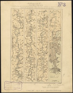
Map of the Mississippi River, from Cairo to the Gulf of Mexico, showing the position of the rebel fortifications at the mouth of the River, those already taken and those remaining to be captured, etc

Item Information
- Title:
- Map of the Mississippi River, from Cairo to the Gulf of Mexico, showing the position of the rebel fortifications at the mouth of the River, those already taken and those remaining to be captured, etc
- Title (uniform):
-
Frank Leslie's illustrated newspaper
- Date:
-
1862
- Format:
-
Maps/Atlases
- Location:
-
Boston Public Library
Norman B. Leventhal Map Center - Collection (local):
-
Norman B. Leventhal Map Center Collection
- Subjects:
-
Fortification--Southern States--Maps
Mississippi River--History--19th century--Maps
Confederate States of America--History--Maps
- Places:
-
Mississippi River
Confederate States of America (area)
Southern United States (area)
- Extent:
- 1 map on 6 sheets ; 155 x 12 cm, sheets 26 x 13 cm.
- Terms of Use:
-
No known copyright restrictions.
No known restrictions on use.
- Publisher:
-
New York :
G. Woolworth Colton
- Scale:
-
Scale varies.
- Language:
-
English
- Notes:
-
Detached from Frank Leslie's Illustrated newspaper, May 10, 1862.
- Identifier:
-
06_01_007449
- Call #:
-
G4042.M5 1862 .M36
- Barcode:
-
39999059031516