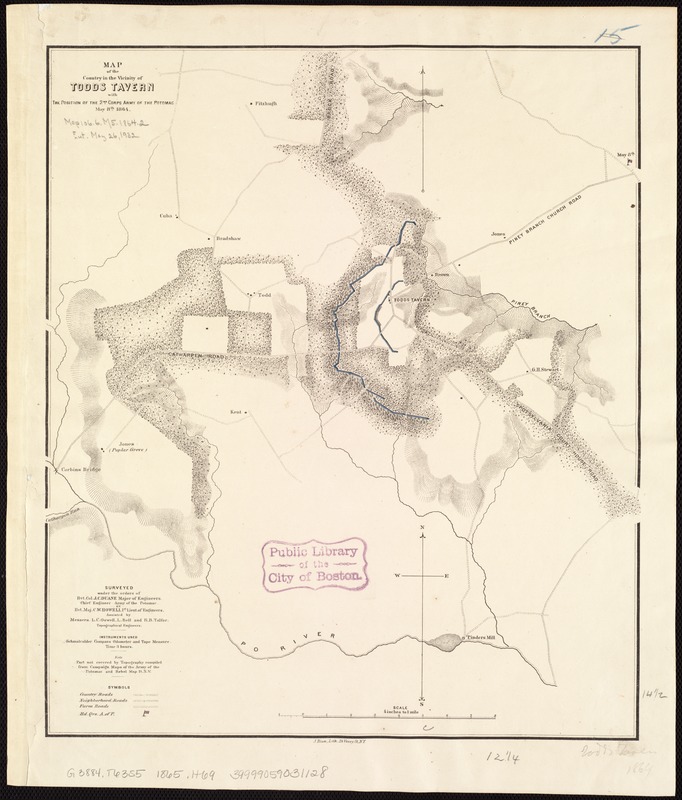
Map of the country in the vicinity of Todds Tavern, with the position of the 2nd Corps Army of the Potomac, May 8th, 1864
Item Information
- Title:
- Map of the country in the vicinity of Todds Tavern, with the position of the 2nd Corps Army of the Potomac, May 8th, 1864
- Title (alt.):
-
Country in the vicinity of Todds Tavern, with the position of the 2nd Corps Army of the Potomac, May 8th, 1864
- Creator:
- Howell, C. W.
- Name on Item:
-
surveyed under the orders of Bvt. Col. J.C. Duane, Major of Engineers, Chief Engineer, Army of the Potomac, by Bvt. Maj. C.W. Howell, 1st Lieut. of Engineers ; assisted by Messers. [sic] L.C. Oswell, L. Bell, and R.B. Talfor, topographical engineers ; J. Bien, lith.,, N.Y.
- Date:
-
[1865?]
- Format:
-
Maps/Atlases
- Location:
-
Boston Public Library
Norman B. Leventhal Map Center - Collection (local):
-
Norman B. Leventhal Map Center Collection
- Subjects:
-
Todds Tavern Region (Va.)--History--19th century--Maps
- Places:
-
Spotsylvania (county)Todds Tavern
- Extent:
- 1 map : hand col. ; 37 x 32 cm.
- Terms of Use:
-
No known copyright restrictions.
No known restrictions on use.
- Publisher:
-
Washington, D.C.? :
s.n.
- Scale:
-
Scale [1:15,840]. 4 in. to 1 mile.
- Language:
-
English
- Notes:
-
Relief shown by hachures.
Includes notes.
- Identifier:
-
06_01_007418
- Call #:
-
G3884.T63S5 1865 .H69
- Barcode:
-
39999059031128
- LCCN:
-
83695216


