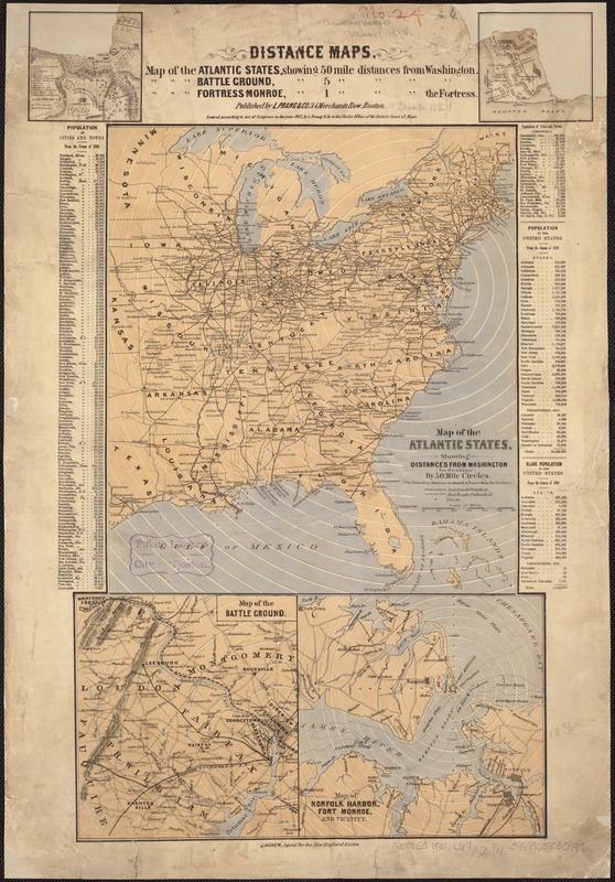
Map of the Atlantic States, showing distances from Washington (in bee line) by 50 mile circles
Item Information
- Title:
- Map of the Atlantic States, showing distances from Washington (in bee line) by 50 mile circles
- Title in upper margin :
- Distance maps
- Creator:
- L. Prang & Co
- Date:
-
[1861]
- Format:
-
Maps/Atlases
- Location:
-
Boston Public Library
Norman B. Leventhal Map Center - Collection (local):
-
Norman B. Leventhal Map Center Collection
- Subjects:
-
United States--Maps
Bull Run (Loudoun County-Fairfax County and Prince William County, Va.)--History--19th century--Maps
Manassas Region (Va.)--History--19th century--Maps
Hampton Roads (Va. : Region)--History--19th century--Maps
Fort Monroe Region (Va.)--History--19th century--Maps
Washington (D.C.)--Distances, etc--Maps
Fort Monroe (Va.)--Distances, etc--Maps
- Places:
-
Manassas (independent city)
Fortress Monroe (defense installation)
Hampton Roads (harbor)
Bull Run
- Extent:
- 5 maps on 1 sheet : col. ; on sheet 59 x 41 cm.
- Terms of Use:
-
No known copyright restrictions.
No known restrictions on use.
- Publisher:
-
Boston :
L. Prang & Co.
- Scale:
-
Scale [ca. 1:8,000,000]
- Language:
-
English
- Table of Contents:
-
Ancillary maps: Map of the battle ground : [Bull Run Region]
Map of Norfolk Harbor, Fort Monroe and vicinity
Position of forces at Bull Run
Fortress Monroe, Old Point Comfort, Virginia.
- Notes:
-
Relief shown by hachures (ancillary maps).
Includes population tables.
- Notes (date):
-
This date is inferred.
- Identifier:
-
06_01_007409
- Call #:
-
G3701.S5 1861 .L67
- Barcode:
-
39999059030997


