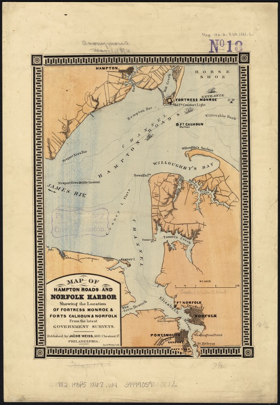
Map of Hampton Roads and Norfolk Harbor : showing the location of Fortress Monroe & Forts Calhoun & Norfolk : from the latest government surveys
Item Information
- Title:
- Map of Hampton Roads and Norfolk Harbor : showing the location of Fortress Monroe & Forts Calhoun & Norfolk : from the latest government surveys
- Creator:
- Weiss, Jacob.
- Name on Item:
-
Jacob Weiss lith.
- Date:
-
[1862?]
- Format:
-
Maps/Atlases
- Location:
-
Boston Public Library
Norman B. Leventhal Map Center - Collection (local):
-
Norman B. Leventhal Map Center Collection
- Subjects:
-
Harbors--Virginia--Norfolk--Maps
Hampton Roads (Va. : Harbor)--Maps
Fort Monroe (Va.)--Maps
Fort Norfolk (Va.)--Maps
Fort Wool (Va.)--Maps
Norfolk (Va.)--Maps
- Places:
-
VirginiaFortress Monroe (defense installation)
VirginiaHampton Roads (harbor)
VirginiaNorfolk (independent city)
Fort Wool (historical)
- Extent:
- 1 map : col. ; 28 x 19 cm.
- Terms of Use:
-
No known copyright restrictions.
No known restrictions on use.
- Publisher:
-
Philadelphia :
Jacob Weiss
- Scale:
-
Scale [ca. 1:160,000].
- Language:
-
English
- Notes:
-
Shows city grids for Hampton, Norfolk & Portsmouth, connecting roads, names of water-ways, and Seaboard & Roanoke Rail Road.
- Identifier:
-
06_01_007387
- Call #:
-
G3882.H3P5 1862 .W4
- Barcode:
-
39999059030872