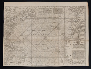
A new chart of the Atlantic or Western Ocean
This map is also available in American Revolutionary Geographies Online (ARGO), a collections portal especially built for material relating to the American Revolutionary War Era. Visit ARGO to learn more about this item and explore the historical geography of North America in the late eighteenth century.
Item Information
- Title:
- A new chart of the Atlantic or Western Ocean
- Creator:
- Heather, William, 1764-1812
- Name on Item:
-
improved by W. Heather ; engraved by J. Stephenson.
- Date:
-
1797
- Format:
-
Maps/Atlases
- Location:
-
Boston Public Library
Norman B. Leventhal Map Center - Collection (local):
-
Norman B. Leventhal Map Center Collection
- Subjects:
-
Nautical charts--North Atlantic Ocean--Early works to 1800
Transatlantic voyages--Maps
North Atlantic Ocean--Maps--Early works to 1800
- Places:
-
Atlantic Ocean
- Extent:
- 1 map ; 93 x 125 cm.
- Terms of Use:
-
No known copyright restrictions.
No known restrictions on use.
- Publisher:
-
London :
Published ... by W. Heather at the Navigation Warehouse, No. 157 Leadenhall Street
- Scale:
-
Scale [ca. 1:9,350,000. At equator]
- Language:
-
English
- Notes:
-
Depths shown by soundings.
Covers North Atlantic Ocean.
Shows tracks of various voyages in the 1790s and arrows for prevailing currents.
In lower left margin: by J. Norie, teacher of navigation, Leadenhall Street.
"Published as the Act directs."
Includes 7 coastal views.
Cataloging, conservation, and digitization made possible in part by The National Endowment for the Humanities: Exploring the human endeavor.
- Identifier:
-
06_01_007371
- Call #:
-
G9100 1797 .H43x
- Barcode:
-
39999059030708