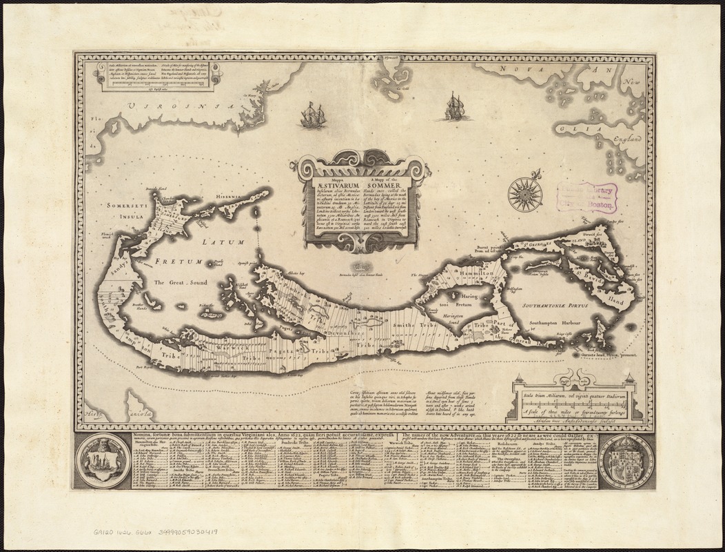
Mappa æstivarum insularum alias Bermudas dictarum ad ostia Mexicani ... accurate descr = A Mapp of the Sommer Islands once called the Bermudas lying at the mouth of the Bay of Mexico ... exactlie surveyed
Item Information
- Title:
- Mappa æstivarum insularum alias Bermudas dictarum ad ostia Mexicani ... accurate descr = A Mapp of the Sommer Islands once called the Bermudas lying at the mouth of the Bay of Mexico ... exactlie surveyed
- Title (alt.):
-
Mappa aestivarum insularum alias Bermudas dictarum ad ostia Mexicani ... accurate descr
Mapp of the Sommer Islands once called the Bermudas lying at the mouth of the Bay of Mexico
- Creator:
- Goos, Abraham.
- Name on Item:
-
Abraham Goos Amstelodamensis sculpsit.
- Date:
-
[ca. 1626]
- Format:
-
Maps/Atlases
- Location:
-
Boston Public Library
Norman B. Leventhal Map Center - Collection (local):
-
Norman B. Leventhal Map Center Collection
- Subjects:
-
Bermuda Islands--Maps--Early works to 1800
- Places:
-
Bermuda (territory)
- Extent:
- 1 map ; 33 x 52 cm.
- Terms of Use:
-
No known copyright restrictions.
No known restrictions on use.
- Publisher:
-
Amsterdam :
Jodocus Hondius
- Scale:
-
Scale ca. 1:51,000.
- Language:
-
Latin
- Notes:
-
Pre-publication proof state, lacking the publisher's imprint, of the map from John Speed's "Prospect of the most famous parts of the world" (London, 1627).
With a key below the map, with Latin and English titles "The names of the now adventurer, viz this yeare 1622 ..." showing the division of Bermuda into the tribes, and the subdivision of each of the tribes, flanked by the arms of Bermuda and of the Virginia colony.
Oriented with north toward the upper right.
Appears in John Speed's A Prospect of the most famous parts of the world. London: Printed by John Dawson for George Humble, 1627.
In Latin and English.
- Identifier:
-
06_01_007260
- Call #:
-
G9120 1626 .G66x
- Barcode:
-
39999059030419