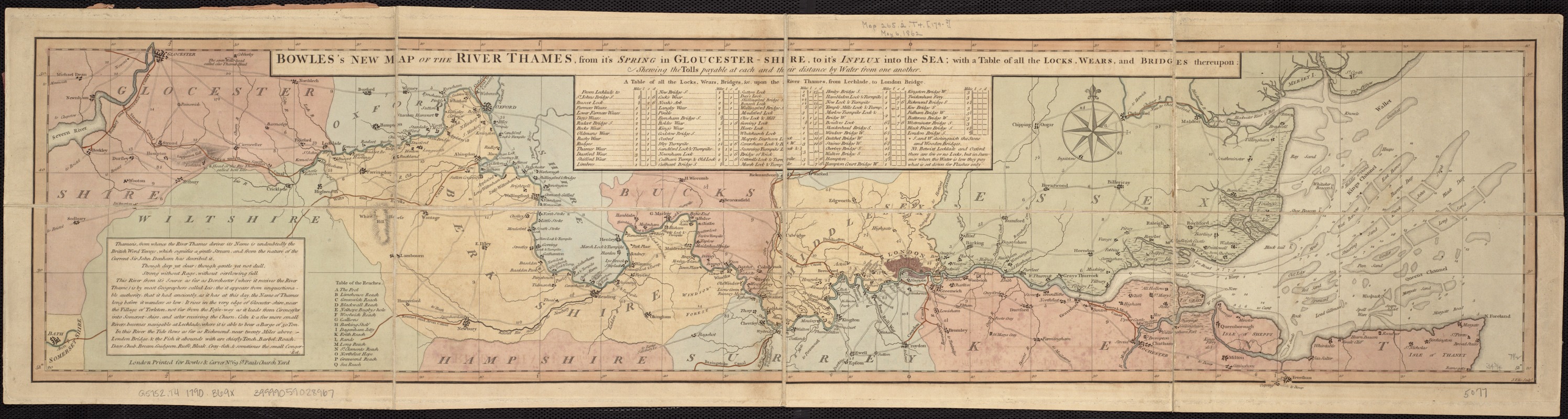
Bowles's new map of the River Thames, from it's spring in Gloucester-shire, to it's influx into the sea : with a table of all the locks, wears, and bridges thereupon ; shewing the tolls payable at each and their distance by water from one another
Item Information
- Title:
- Bowles's new map of the River Thames, from it's spring in Gloucester-shire, to it's influx into the sea : with a table of all the locks, wears, and bridges thereupon ; shewing the tolls payable at each and their distance by water from one another
- Creator:
- Bowles, Carington, 1724-1793
- Engraver:
- Ellis, John
- Date:
-
[1790?–1799?]
- Format:
-
Maps/Atlases
- Location:
-
Boston Public Library
Norman B. Leventhal Map Center - Collection (local):
-
Norman B. Leventhal Map Center Collection
- Subjects:
-
Thames River (England)--Navigation
Thames River (England)--Maps
- Places:
-
EnglandThames (river)
- Extent:
- 1 map : col. ; 21 x 89 cm.
- Terms of Use:
-
No known copyright restrictions.
No known restrictions on use.
- Publisher:
-
London :
Printed for Bowles & Carver
- Scale:
-
Scale not given.
- Language:
-
English
- Notes:
-
London meridian.
"J. Ellis Sculp."
Table of locks, wears, bridges &c.
Sandbars, shoals and soundings shown in estuary.
River Thames from head near Torleton, Gloucestershire through Lechlade, Oxford, Abingdon, Wallingford, Reading, Henley, Maidenhead, Windsor, London and to the sea.
- Identifier:
-
06_01_006974
- Call #:
-
G5752.T4 1790 .B69x
- Barcode:
-
39999059028967