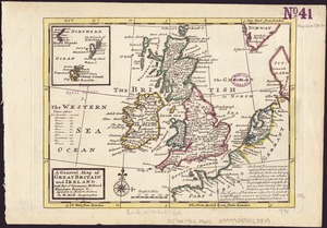
A new map of the Brittish Isles shewing their present genl. divisions, cities, and such other towns, or places, as answer to the towns of note in the time of the Romans : dedd. to His Highness William, Duke of Glocester
Item Information
- Title:
- A new map of the Brittish Isles shewing their present genl. divisions, cities, and such other towns, or places, as answer to the towns of note in the time of the Romans : dedd. to His Highness William, Duke of Glocester
- Title (alt.):
-
New map of the British isles showing their present genl. divisions, cities, and such other towns, or places, as answer to the towns of note in the time of the Romans
- Creator:
- Wells, Edward, 1667-1727
- Name on Item:
-
Sutton Nicholls sculp.
- Date:
-
1719
- Format:
-
Maps/Atlases
- Location:
-
Boston Public Library
Norman B. Leventhal Map Center - Collection (local):
-
Norman B. Leventhal Map Center Collection
- Subjects:
-
British Isles--Maps--Early works to 1800
- Places:
-
British Isles (area)
- Extent:
- 1 map : outline col. ; 37 x 48 cm.
- Terms of Use:
-
No known copyright restrictions.
No known restrictions on use.
- Publisher:
-
London :
Printed by T.W. for R Bonwicke, J. Walthoe, R. Wilkin, and T. Ward, 1719]
- Scale:
-
Scale [1:2,851,200].
- Language:
-
English
- Notes:
-
Relief shown pictorially.
Appears in the author's A new sett of maps both of antient and present geography. London : Printed by T.W. for R Bonwicke, J. Walthoe, R. Wilkin, and T. Ward, [1719?].
- Identifier:
-
06_01_006965
- Call #:
-
G5740 1719.2 .W45
- Barcode:
-
39999059028868