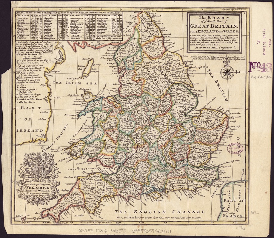
The roads of ye south part of Great Britain, called England and Wales : Containing all ye cities, market towns, post towns, boroughs: and whatever places have ye election of members of parliament &c. all the great or post roads, and principal cross-roads &c. with ye computed miles from town to town
Item Information
- Title:
- The roads of ye south part of Great Britain, called England and Wales : Containing all ye cities, market towns, post towns, boroughs: and whatever places have ye election of members of parliament &c. all the great or post roads, and principal cross-roads &c. with ye computed miles from town to town
- Creator:
- Moll, Herman, d. 1732
- Publisher:
- Bowles, John, 1701-1779
- Publisher:
- Bowles, Thomas, 1694-1773
- Name on Item:
-
by Herman Moll.
- Date:
-
[1732?]
- Format:
-
Maps/Atlases
- Location:
-
Boston Public Library
Norman B. Leventhal Map Center - Collection (local):
-
Norman B. Leventhal Map Center Collection
- Subjects:
-
England--Maps--Early works to 1800
Wales--Maps--Early works to 1800
- Places:
-
England
- Extent:
- 1 map : outline col. ; 28 x 30 cm.
- Terms of Use:
-
No known copyright restrictions.
No known restrictions on use.
- Publisher:
-
[London] :
Printed and sold by T. Bowles ... & I. Bowles ...
- Scale:
-
Scale [ca. 1:2,000,000].
- Language:
-
English
- Notes:
-
Notes about the counties ; dedicatory cartouche.
Shows boundaries, rivers and settlements.
London meridian.
"Note. This map has been copied four times very confused and scandalously."
England and Wales, divided into counties.
- Identifier:
-
06_01_006951
- Call #:
-
G5750 1732 .M65
- Barcode:
-
39999059028801