Plans & views of Rebel defences, coast of South Carolina
Item Information
- Title:
- Plans & views of Rebel defences, coast of South Carolina
- Title (alt.):
-
Plans and views of Rebel defences, coast of South Carolina
- Creator:
- Willenbücher, Eugene.
- Name on Item:
-
drawn by E. Willenbucher, under the direction of C. O. Boutelle, Assist., U.S. Coast Survey.
- Date:
-
1862
- Format:
-
Maps/Atlases
- Location:
-
Boston Public Library
Norman B. Leventhal Map Center - Collection (local):
-
Norman B. Leventhal Map Center Collection
- Subjects:
-
Fortification--South Carolina--Maps
South Carolina--History--Civil War, 1861-1865--Maps
- Places:
-
South Carolina
- Extent:
- 7 plans ; on sheet 65 x 45 cm.
- Terms of Use:
-
No known copyright restrictions.
No known restrictions on use.
- Publisher:
-
Washington, D.C :
[U.S. Coast Survey]
- Scale:
-
Scales differ.
- Language:
-
English
- Notes:
-
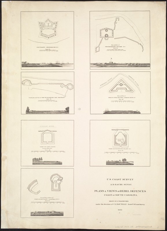
Contents: Fort "Walker," Hilton Head Isld., S.C. Scale 1:2000. 17 x 15 cm. -- Ground plan and view of fort on Botany-Bay Isld. North Edisto R. Scale 1:2000. 12 x 15 cm. -- Fort on Sam's Point, Coosaw River, S.C. Scale 1:1000. 13 x 15 cm. -- Ground plan and view of fort on Bay Point South Edisto R., S.C. Scale 1:1000. 14 x 15 cm. -- Plan and view of Fort "Beauregard," Bay Point, S.C. Scale 1:2000. 17 x 17 cm. -- Plan and view of fort on Otter Isld. Point, St. Helena Sound, S.C. Scale 1:1600. 12 x 17 cm. -- Fort on Fenwick's Island, S.C. Scale 1:1000. 13 x 17 cm.
At the bottom of each map is a view of the fort.
Description derived from published bibliography.
- Identifier:
-
06_01_006853
- Call #:
-
G3911.S5 1862 .W5
- Barcode:
-
39999059028728
- LCCN:
-
99448809


